
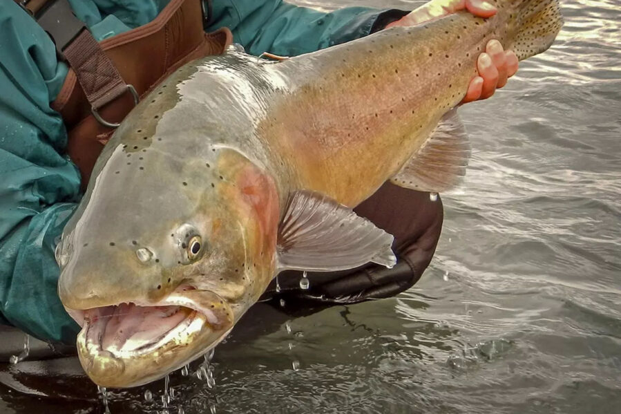
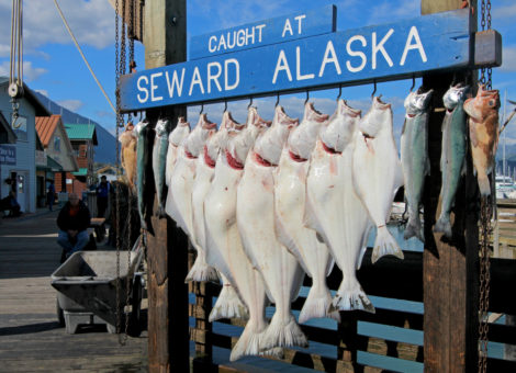
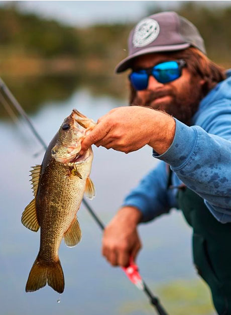
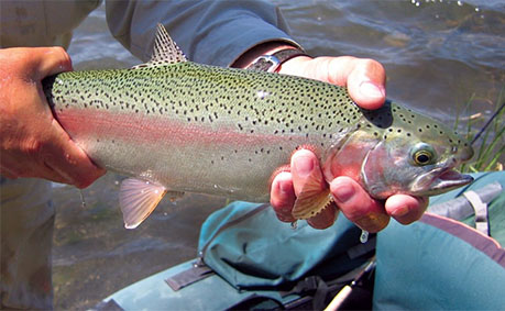
The High Uinta Mountains located in northeastern Utah are home to over 1,000 natural lakes of which more than 650 support wild and introduced populations of game fish—predominently Bonneville and Colorado River cutthroat trout, brook trout, brown trout, golden rainbow trout, and grayling. To a lesser degree anglers will also find limited populations of warm water fish such as largemouth bass, smallmouth bass, bluegill, crappie, and tiger musky.
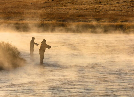
The Uintas offer a one-of-a-kind fishing experience that should be on every angler’s bucketlist. The Uinta fishery can be fished either baitcasting or fly fishing tackle, and supports a seemingly limitless number of rivers and creeks that are best tackled with a fly rod and reel. With so many diverse fishing opportunities, you couldn’t hope to fish the Uintas in a lifetime. (It’s been attempted.)
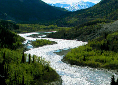
The Uinta Mountain range offers some of the best fishing, but it has unpredictable weather, challenging terrain and is an unforgiving environment for the unprepared. Additionally, fishing can also be unpredictable. You may have no success in one lake and then hook a 5 pound brown trout in the next. I’ve often had to fish several streams before finding a sweet spot.
The following information tables and maps have been compiled to help you fully research, plan, and prepare for a fishing trip to the High Uintas. Tables and maps are organized by drainage area. ONLY fishing lakes are included. The Uintas are divided into 14 major drainages. Along with each drainage area is a link to a PDF file providing more extensive information and details for the lakes and fisheries located within the drainage.
- Ashley Creek Drainage
- Bear River Drainage
- Beaver Creek Drainage
- Blacks Fork Drainage
- Dry Gulch Drainage
- Uinta River Drainage
- Duchesne River Drainage
- Henrys Fork Drainage
- Provo River Drainage
- Rock Creek Drainage
- Sheep Creek/Carter Creek Drainage
- Burnt Fork Drainages
- Smiths Fork Drainage
- Weber River Drainage
- Whiterocks Drainage
- Yellowstone River Drainage
- Lake Fork Drainage
- Swift Creek Drainage
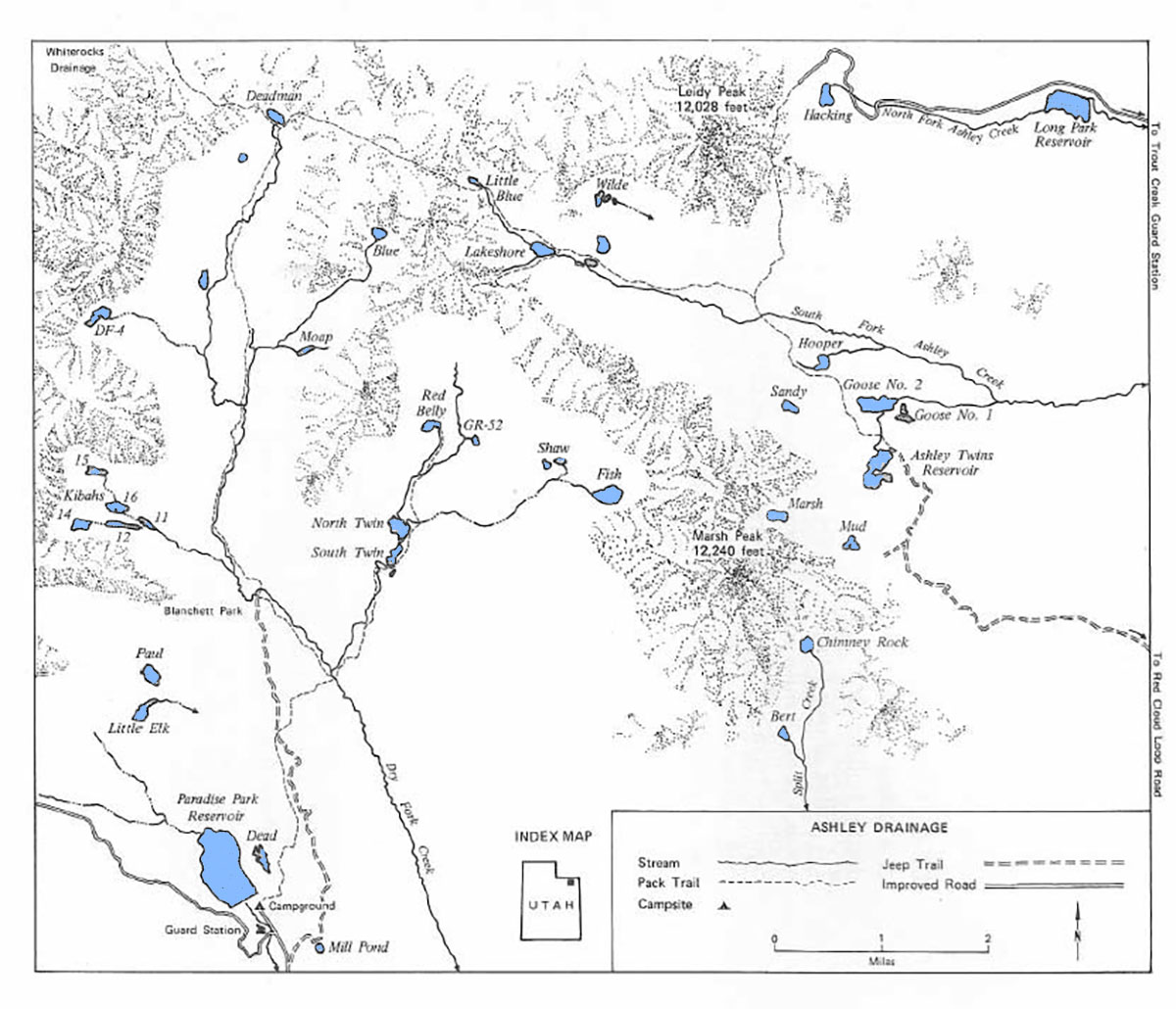
Ashley Creek Drainage
Ashley Creek Drainage is divided into Dry Fork Creek, South Fork and North Fork. There are over 70 lakes in the Ashley Creek Drainage of which 27 hold natural reproducing trout populations, including brook, cutthroat and a few rainbows.
There are three trailheads into Ashley Creek Drainage. The Dry Fork access found at the Paradise Park Reservoir camground, Ashley Twins Reservoir and a final access 1/2 mile west of Hacking Lake.
Ashley Twins Reservoir serves as the starting point to reach lakes in the South Fork of Ashley Creek. There is 5.5 mil road (accessible by 4×4) from Red Cloud Loop that will take you to Ashley Twins Reservoir.
To reach Hacking Lake there is a road accessible at the Trout Creek Guard Station and runs west 7 miles. 1/2 mile west of Hacking Lake there is a trailhead that provides access to Lakeshore Basion (South Fork of Ashley Creek).
| Lake name | Size (acres) | Max depth (ft) | Fish species | Fishing pressure |
|---|---|---|---|---|
| Ashley Twins Reservoir, GR-35 | 25 | 18 | Brook trout, cutthroat trout (reproducing) | Moderate |
| Bert, FR-62 | 3.7 | 11 | Brook trout (stocked) | Low |
| Blue, DF-1 | 6.5 | 16 | Brook trout | Moderate |
| Deadman, GR-38 | 7 | 9 | Brook trout, cutthroat trout | High |
| DF-4 | 10 | 23 | Cutthroat | Low |
| East Kibah, DF-11 | 2.9 | 12 | Brook trout (stocked), rainbow trout (reproducing) | Moderate |
| Finger Kibah, DF-12 | 4.7 | 9 | Brook trout | Moderate |
| West Kibah, DF-14 | 7.8 | 15 | Brook trout (stocked) | Moderate |
| Island Kibah, DF-16 | 8 | 14 | Brook trout | Moderate |
| Fish, GR-57 | 17.5 | 40 | Cutthroat trout (reproducing) | High |
| Goose #2, GR-43 | 19.4 | 15 | Cutthroat | Low |
| GR-52 | 2.1 | 4 | Brook trout | Moderate |
| Hooper, GR-46 | 4.5 | 4 | Cutthroat trout | Moderate |
| Lakeshore, GR-34 | 11.1 | 18 | Brook and cutthroat trout | Moderate |
| Little Blue, GR-48 | 3.2 | 6 | Brook trout | Low |
| March, GR-39 | 12.6 | 21 | Brook trout | Moderate |
| North Twin (Dry Fork), GR-50 | n/a | n/a | Brook and cutthroat trout | High |
| Paul, DF-18 | 11.1 | 17 | Brook trout | Low |
| Red Belly, GR-51 | 6.3 | 8 | Cutthroat trout | Moderate |
| Sandy, GR-45 | 5.6 | 10 | Cutthroat trout | Low |
| Shaw, GR-59 | 2.8 | 5 | Cutthroat trout | Low |
| South Twin (Dry Fork), GR-49 | 6.2 | 8 | Brook and cutthroat trout | High |
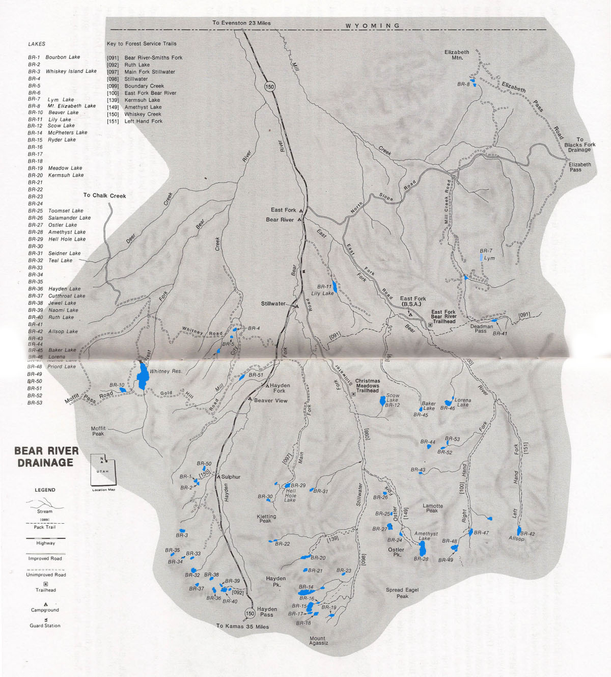
Bear River Drainage
The Bear River Drainage is the largest drainage in the Uintas. It is located in the northwestern extremity of the Uinta range. Most of the drainage area is rugged with a few narrow drainage basins in the east and timbered ridges to the west.
The drainage include 6 major tributary systems including the West Fork, Hayden Fork, Main Fork, Stillwater Fork, East Fork and the Mill Creek Drainage. The West Fork and Mill Creek areas are not open to public access. The drainage has 38 lakes, a reservoir, and several small lakes. Most lakes contain populations of brook or cutthroat trout. A few lakes are stocked with rainbow trout.
The Bear River Drainage is accessible via the Mirror Lake Highway (U-150) east and north of city of Kamas, Utah and south of Evanston, Wyoming. Other access points include Forest Service routes includinge Whitney, Gold Hill, Stillwater, North Slope, East Fork and Mill Creek Roads. Backcountry access areas include the Christmas Meadows and East Fork-Bear River Trailheads and Ruth Lake and Whiskey Creek Trail turnouts on U-150.
A few of the lakes in the Bear River Drainage are accessible by road, but the majority are remote and accessibe only by trail. The most popular access trails include the Bear River-Smiths Fork Trail, the Main Fork Stillwater Trail, the Ruth Lake Trail, the Boundary Creek Trail, the Stillwater Trail, the East Fork Bear River Trail, the Kermsuh Lake Trail, the Amethyst Lake Trail, the Left Hand Fork Trail, and the Whiskey Creek Trail. Each of these trail systems is identified by a Forest Service trail number.
The most popular fishing lakes in the drainage are Ruth, Bourbon, Lyrn, Teal, Beaver and Whitney Reservoir. If you’re seeking solitude, these are the lakes you’ll want to avoid.
| Lake name | Size (acres) | Max depth (ft) | Fish species | Fishing pressure |
|---|---|---|---|---|
| Allsop, BR-42 | 12.3 | 22 | Cutthroat (natural reproducing) | Moderate |
| Amethyst | 42.5 | 59 | Brook and cutthroat trout | Moderate |
| Baker, BR-45 | 3.6 | 8 | Tiger trout | Moderate |
| Beaver, BR-10 | 13.2 | 32 | Rainbow, brook and cutthroat trout | Moderate |
| Bourbon (Gold Hill), BR-1 | 1.9 | 8 | Brook trout | Moderate |
| BR-2 | 0.7 | 5 | Brook trout | Low |
| BR-16 | 1 | 5 | Brook and cutthroat trout (natural reproducing) | Low |
| BR-17 | 2.8 | 7 | Brook trout (natural reproducing) | Moderate |
| BR-18 | 4.8 | 12 | Brook trout | Low |
| BR-24 | 2.4 | 10 | Tiger trout | Low |
| BR-44 | 3.6 | 15 | Tiger trout | Low |
| Cutthroat, BR-37 | 3.8 | 16 | Cutthroat and tiger trout | Moderate |
| Hayden, BR-36 | 4.4 | 5 | Tiger trout | Moderate |
| Kermush | 12.4 | 14 | Cutthroat trout (natural reproducing) | Low |
| Lily, BR-11 | 12.6 | 20 | Rainbow trout | Moderate |
| Lorena, BR-46 | 12 | 20 | Brook trout (stocked) | Low |
| Lym, BR-7 | 6.4 | 20 | Brook trout (natural reproducing) | Moderate |
| McPheters, BR-14 | 28 | 45 | Tiger trout | Moderate |
| Meadow, BR-19 | 2.9 | 5 | Brook trout (natural reproducing) | Low |
| Mt. Elizabeth, BR-8 | 3.1 | 15 | Cutthroat trout | Moderate |
| Norice, BR-47 | 4.8 | 3 | Cutthroat trout (natural reproducing) | Moderate |
| Ostler, BR-27 | 14 | 14 | Tiger trout | Moderate |
| Priord, BR-48 | 12 | 20 | Cutthroat trout (stocked), Tiger trout | Moderate |
| Ruth, BR-40 | 9.7 | 30 | Brook trout (stocked) | High |
| Ryder, BR-15 | 23.7 | 55 | Brook trout | Moderate |
| Salamander, BR-26 | 4.1 | 13 | Brook trout (stocked) | Low |
| Scow, BR-12 | 22.9 | 6 | Brook trout | Low |
| Seidner, BR-31 | 3.2 | 8 | Brook trout (natural reproducing) | Moderate |
| Teal, BR-32 | 6.9 | 14 | Tiger trout | Moderate |
| Toom Set, BR-25 | 2.1 | 11 | Brook trout (natural reproducing) | Low |
| Whiskey Island (Guy's) BR-3 | 5 | 19 | Arctic grayling | Low |
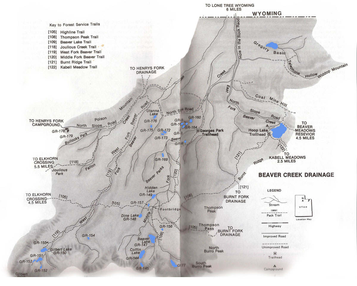
Beaver Creek Drainage
Beaver Creek Drainage is a remote area located on the north slope of the Uinta Mountain Range approximately 10 miles south of Lonetree, Wyoming. It is characterized by apline basins, timbered ridges and several small lakes. The basin comprises the West Fork, Middle Fork and East Fork drainage systems.
Given its remoteness, fishing pressure is low. Anglers rarely make the effort to visit and fish Beaver Creek’s backcountry lakes. If you want to catch trout, and are looking for a little solitude, Beaver Creek Drainage is a great place to plan a fishing adventure.
Bearver Creek Drainage is home to 40 lakes, one large reservoir and a various small ponds. Only 12 of these bodies of water have fish populations. Brookies and cutthroats are the most common catches. If you want to target rainbows, visit Hoop Lake in the East Fork Drainage. Most trout populations are naturally reproducing. Aerial stockings of fingerlings are scheduled every few years as required to maintain trout populations.
The easiest way to access Beaver Creek Drainage is via the Hole in the Rock Road for Lontree, Wyoming and the North Slope Road accessible from Henry Fork Drainage or Burnt Fork Drainage. There are three trails that provide acess to Beaver Creek wilderness area. These include the West Fork Beaver Trail (accessible from West Fork Road), the Thompson Peak Trails (accessible from the Hoop Lake Trailhead), and the Middle Fork Beaver Trail (accessible from Georges Park Trailhead).
| Lake name | Size (acres) | Max depth (ft) | Fish species | Fishing pressure |
|---|---|---|---|---|
| Beaver, GR-147 | 38.3 | 30 | Brook trout (natural reproducing), Cutthroat | High |
| Coffin, GR-144 | 25.8 | 28 | Cutthroat (stocked), Tiger trout | Low |
| Dine, GR-148 | 5.1 | 15 | Brook trout | Low |
| Gilbert, GR-150 | 15.2 | 2 | Brook and cutthroat trout (natural reproducing) | Moderate |
| GR-145 | 5.6 | 11 | Cutthroat (variable), Arctic grayling | Low |
| GR-151 | 12.6 | 11 | Brook trout (natural reproducing) | Low |
| GR-152 | 4.8 | 13 | Brook trout | Low |
| GR-153 | 3.6 | 2 | Brook and cutthroat trout | Low |
| GR-154 | 2.1 | 6 | Brook trout (stocked) | Low |
| GR-155 | 1.6 | 6 | Brook trout (stocked) | Low |
| GR-160 | 4.8 | 50 | Brook trout | Low |
| GR-161 | 4.3 | 41 | Brook trout (variable) | Low |
| GR-162 | 6.5 | 18 | Brook trout (variable) | Low |
| GR-163 | 6.5 | 16 | Brook trout (variable) | Low |
| GR-172 | 3.6 | 15 | Brook trout (variable) | Low |
| GR-173 | 3.9 | 27 | Brook trout (variable) | Low |
| GR-175 | 18.3 | 11 | Cutthroat trout | Low |
| GR-179 | 5.5 | 11 | Brook trout (variable) | Low |
| Hidden, GR-149 | 6.5 | 18 | Brook trout (stocked) | Moderate |
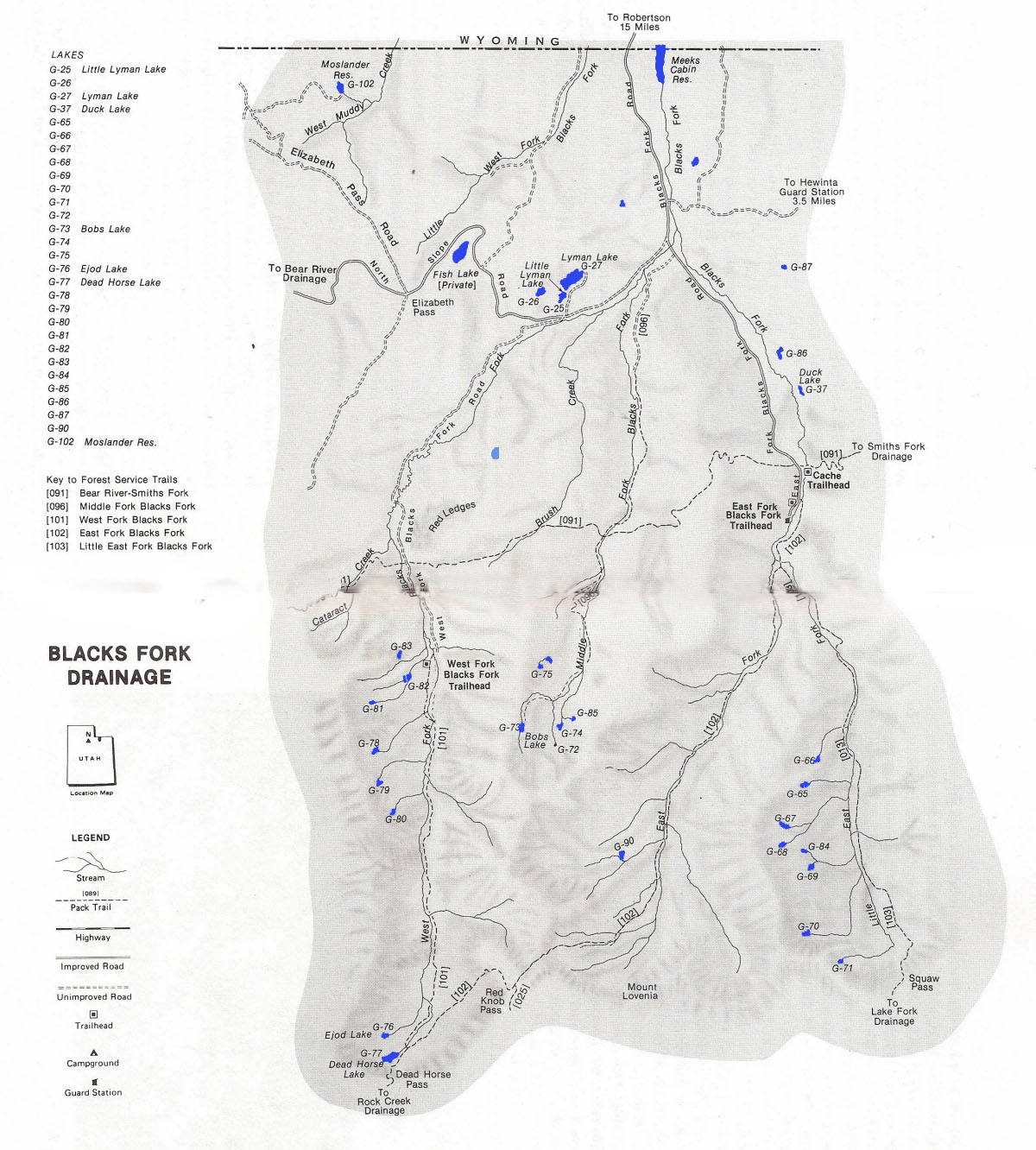
Blacks Fork Drainage
Blacks Fork Drainage is located on the north slope of the Uintas. It is composed of 4 tributaries, including West Fork, Middle Fork,
East Fork and Little East Fork. Blacks Fork Drainage is a rugged alpine tundra composed of narrow river valleys.
There are 33 lakes, 3 reservoirs and over 100 smaller (smaller than 2 acre) ponds located throughout the 4 tributaries. You’ll find trout in about half of these waters.
Blacks Fork Drainage is about 15 miles south of U-150 on North Slope Road and 18 miles southwest of Robertson, Wyoming. There are several trails that provide access to back country wilderness areas in the drainage. These include Bear River-Smith Fork Trail, the East Fork Blacks Fork Trail, the West Fork Blacks Fork Trail, the Little East Fork Blacks Fork Trail and the Middle Fork Blacks Fork Trail.
If you’re looking for peace and solitude, it doesn’t get any better than Blacks Fork Drainage. Most fishing lakes are located some distance from the road and accessible by foot. Only 5 of the lakes can be reached directly by road or trail. Fishing pressure is low in this drainage.
The most popular catches in the Blacks Fork Basin are brook and cutthroat trout. Most trout populations reproduce naturally. Brook and cutthroat populations are augmented periodically by aerial stocking. In the Lyman Lakes, where fishig pressure is higher, brook trout are stocked regularly, as are rainbows. A few lakes offer the possibility of tiger trout and graylings.
If you plan on doing much fishing in the Blacks Fork Drainage, make sure to carefully plan your trip ahead of time. The terrain is rugged, lakes are remote, and there is a bit of distance between fishable waters.
| Lake name | Size (acres) | Max depth (ft) | Fish species | Fishing pressure |
|---|---|---|---|---|
| Bobs, G-73 | 6.6 | 30 | Cutthroat trout (stocked), Tiger trout | Low |
| Dead Horse, G-77 | 16 | 41 | Cutthroat trout (stocked), Tiger trout | Moderate |
| Duck, G-37 | 5.9 | 5 | Brook trout (stocked) | Moderate |
| Ejod, G-76 | 6.7 | 12 | Cutthroat trout (natural & stocked) | Low |
| G-65 | 5 | 5 | Brook trout (natural reproducing) | Moderate |
| G-66 | 4 | 12 | Brook trout (natural reproducing) | Moderate |
| G-67 | 7.7 | 25 | Brook trout (stocked) | Low |
| G-69 | 4.8 | 13 | Cutthrout (natural reproducing) | Low |
| G-70 | 3.8 | 4 | Cutthroat trout (stocked) | Low |
| G-71 | 4.8 | 14 | Brook trout | n/a |
| G-72 | 1.3 | 6 | Unknown | Low |
| G-74 | 3.4 | 3 | Brook trout | Low |
| G-78 | 3.2 | 9 | Brook trout | Low |
| G-79 | 2.5 | 5 | Brook trout | Low |
| G-80 | 1.8 | 8 | Brook trout | Low |
| G-81 | 1.6 | 5 | Cutthrout trout (stocked) | Low |
| G-82 | 3.8 | 6 | Brook trout | Low |
| G-86 | 6.4 | 7 | Brook trout | Low |
| Little Lyman, G-25 | 5 | 25 | Rainbow trout (stocked) | High |
| Lyman, G-27 | 36.6 | 30 | Rainbow trout (stocked) | Moderate |
| Moslander, G-102 | 11.4 | 29 | Brook trout | Low |
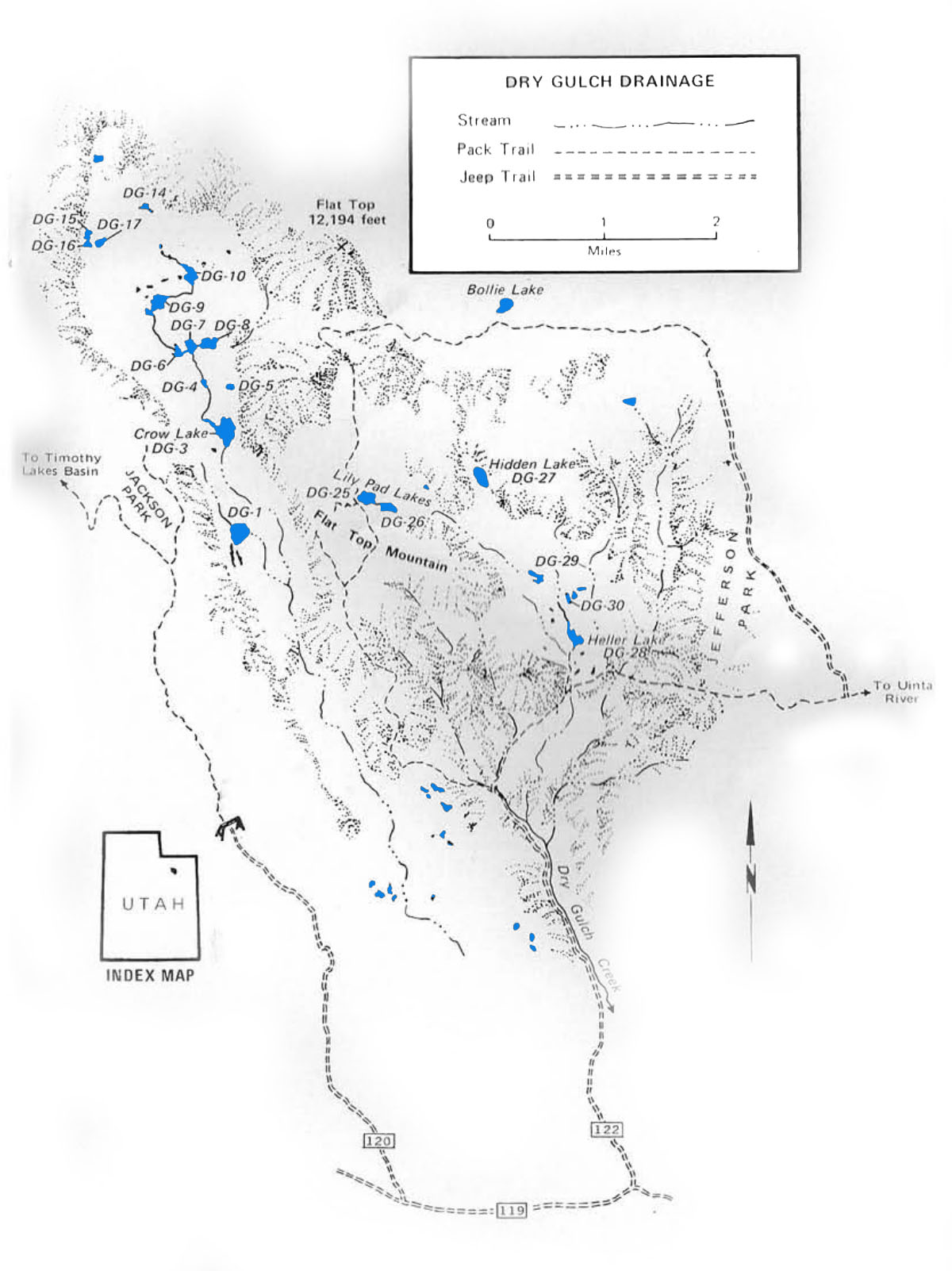
Dry Gulch Drainage
Dry Gulch is located between the Uinta River and Swift Creek Drainages, approximately 15 miles northeast of the city of Altamont, Utah. It is a relatively small drainage composed of the Heller and Crow basins.
The Heller Basin has 1 reservoir, 3 lakes and just over 30 small ponds. The reservoir and the lakes are the only managed fisheries, but you may also find fish in some of the ponds. The terrain is not as rugged as other drainages in the Uinta range. It is characterized by talus ridges covered by conifer pines and narrow damp meadows. Heller basin is accessed via Dry Gulch Rd (No.122) north of Altamont near the boundary dividing the U.S. Forest Service and Indian Reservation.
Crow basin is long and narrow surrounded by steep rock walls. The floor of the basin is composed of meadows and rigdes covered in conifers. There are 11 lakes that are bigger than 2 acres and several smaller ponds. Not all the lakes are stocked with trout and fishing can be hit or miss. The basin is accessed via the Timothy Creek jeep trail (no.120) located north of Altamont or Neola about 2 miles west of the Dry Gulch turnoff. From there travel 6 miles along Timothy Creek Road to Jackson Park which borders Crow Basin.
Crow Basin can also be accessed from Heller Basin. Follow the Lily Pad lakes trail northwest from Heller Basin over the Flat Top Mountain into Crow Basin. The Crow Basin receives relatively low fishing pressure compared to Heller Basin due to its inaccessibility.
| Lake name | Size (acres) | Max depth (ft) | Fish species | Fishing pressure |
|---|---|---|---|---|
| Crow, DG-3 | 18 | 26 | Cutthroat trout | Moderate |
| DG-6 | 3 | 5 | Cutthroat trout (stocked) | Low |
| DG-7 | 6 | 4 | Cutthroat trout | Low |
| DG-8 | 7 | 8 | Cutthroat trout | Low |
| DG-9 | 10 | 27 | Cutthroat trout | Low |
| DG-10 | 10 | 12 | Cutthroat trout | Low |
| DG-14 | 2 | 10 | Cutthroat trout (stocked) | Low |
| DG-15 | 3 | 9 | Cutthroat trout | Low |
| DG-16 | 3 | 8 | Cutthroat trout | Low |
| DG-17 | 3 | 12 | Cutthroat trout | Low |
| Heller Reservoir, DG-28 | 12 | 37 | Brook trout | High |
| Hidden, DG-27 | 10 | 39 | Brook trout | Low |
| Lower Lily Pad, DG-26 | 9 | 11 | Brook trout | Low |
| Upper Lily Pad, DG-25 | 12 | 37 | Brook and cutthroat trout | High |
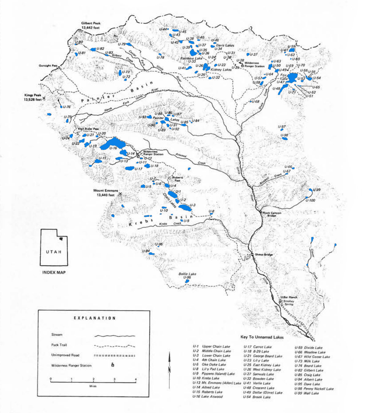
Uinta River Drainage
The Uinta River Drainage is among the largest in the Uinta Mountain Range. It is comprised of seven major basins including Painter, Painter Lakes, Atwood, Krebs, Gilbert, Fox-crescent and Kidney Lakes, as well as several smaller basins. The seven basins are accessible by foot or horse.
The Uinta Canyon Trailhead and West Fork of the Whiterocks River drainage provide the main access to the Uinta River Drainage. The Uinta Canyon trail is located 21 miles north of Neola, Utah. It provides access to the western region of the Uinta River drainage. The West Fork of the Whiterocks River drainage is locate 25 miles north of Whiterocks, Utah. It provides access to the eastern region of the drainage.
The Uinta River Drainage has over 90 lakes and ponds. Over half of these lakes support productive trout fisheries. The most abundant fish species in the Uinta River Drainage are book and cutthroat trout. A few lakes also contain rainbow and golden trout. Streams and tributaries to the major lakes usually provide good trout fishing as well.
The heaviest fishing pressure is at Kidney lakes, Chain lakes, Fox-Cresent lakes and Atwood lakes. If you’re looking for peace and quite, you’ll want to avoid these lakes during the mid-summer months.
| Lake name | Size (acres) | Max depth (ft) | Fish species | Fishing pressure |
|---|---|---|---|---|
| Albert, U-94 | 7 | 8 | Cutthroat trout | Low |
| Allred, U-14 | 34 | 30 | Brook trout | Moderate |
| Atwood, U-16 | 200 | 40 | Brook trout and golden trout | Moderate |
| B-29 Lake, U-18 | 19 | 7 | Brook trout | Low |
| Bear, U-74 | 9 | 15 | Brook trout (stocked) | Low |
| Bollie, U-96 | 10 | 15 | Cutthroat trout | Low |
| Bowden, U-32 | 4.5 | 14 | Brook trout (stocked) | Moderate |
| Brook, U-54 | 10 | 8 | Brook trout (stocked) | Low |
| Carrot, U-17 | 31 | 31 | Brook trout (stocked) | Low |
| Chain 1 (Lower), U-3 | 62 | 38 | Brook trout (natural reproducing) | High |
| Chain 2 (Middle), U-2 | 14.4 | 13 | Brook trout (natural reproducing) | Moderate |
| Chain 3 (Upper), U-1 | 51 | 44 | Brook trout | Moderate |
| Chain 4, U-4 | 13.5 | 31 | Cutthroat trout | Low |
| Craig, U-85 | 9.3 | 14 | Cutthroat and brook trout | Low |
| Crescent, U-48 | 31 | 23 | Cutthroat and brook trout | Moderate high |
| Davis, North, U-46 | 7.3 | 7 | Brook trout | Low |
| Davis, South, U-34 | 6.1 | 4 | Brook trout | Low |
| Divide, U-59 | 18.9 | 39 | Cutthroat trout | Low |
| Dollar, U-49 | 11.5 | 6 | Brook trout | Moderate |
| Fox, U-47 | 102 | 47 | Brook and cutthroat trout | Moderate |
| George Beard, U-21 | 7.4 | 15 | Brook trout (natural reproducing) | Low |
| Gilbert, U-82 | 14.6 | 20 | Brook trout (stocked) | Low |
| Kidney, East, U-25 | 13.7 | 12 | Brook trout | High |
| Kidney, West, U-26 | 20 | 4 | Brook trout | High |
| Lily, U-23 | 5.3 | 15 | Brook trout | Low |
| Lily Pad, U-8 | 3.7 | 7 | Brook and rainbow trout (natural reproducing) | Moderate |
| Milk, U-73 | 13.1 | 35 | Brook and cutthroat trout | Low |
| Mt. Emmons, U-13 | 15.5 | 21 | Brook trout, Golden Trout | Low |
| Oke Doke, U-5 | 12.9 | 38 | Cutthroat (stocked) | Low |
| Penny Nickell, U-98 | 11.5 | 43 | Cutthroat (stocked) | Low |
| Pippen, U-9 | 3.2 | 3 | Brook trout (natural reproducing) | Moderate |
| Rainbow, U-33 | 35.1 | 20 | Brook trout (natural reproducing) | Moderate |
| Roberts, U-15 | 23.3 | 38 | Cutthroat and brook trout | Low |
| Samuals, U27 | 4.8 | 7 | Brook trout | Low |
| U-19 | 15 | 8 | Brook trout, Golden trout | Low |
| U-35 | 4.4 | 5 | Cutthroat and brook trout | Moderate |
| U-36 | 4.6 | 7 | Brook trout (natural reproducing) | Moderage |
| U-37 | 6.3 | 12 | Brook trout (stocked) | Low |
| U-38 | 15.7 | 13 | Cutthroat trout | Moderate |
| U-42 | 7.6 | 7 | Cutthroat trout | Low |
| U-45 | 5 | 5 | Cutthroat trout | Low |
| U-50 | 18 | 8 | Brook trout | Low |
| U-75 | 6.9 | 18 | Brook trout | Low |
| U-76 | 6 | 15 | Cutthroat trout | Low |
| U-88 | 14 | 18 | Brook trout | Low |
| U-89 | 11.5 | 15 | Brook trout | Low |
| U-93 | 11.1 | 8 | Cutthroat trout (stocked) | Very low |
| Verlie, U-41 | 10.6 | 12 | Brook trout (natural reproducing) | Moderate |
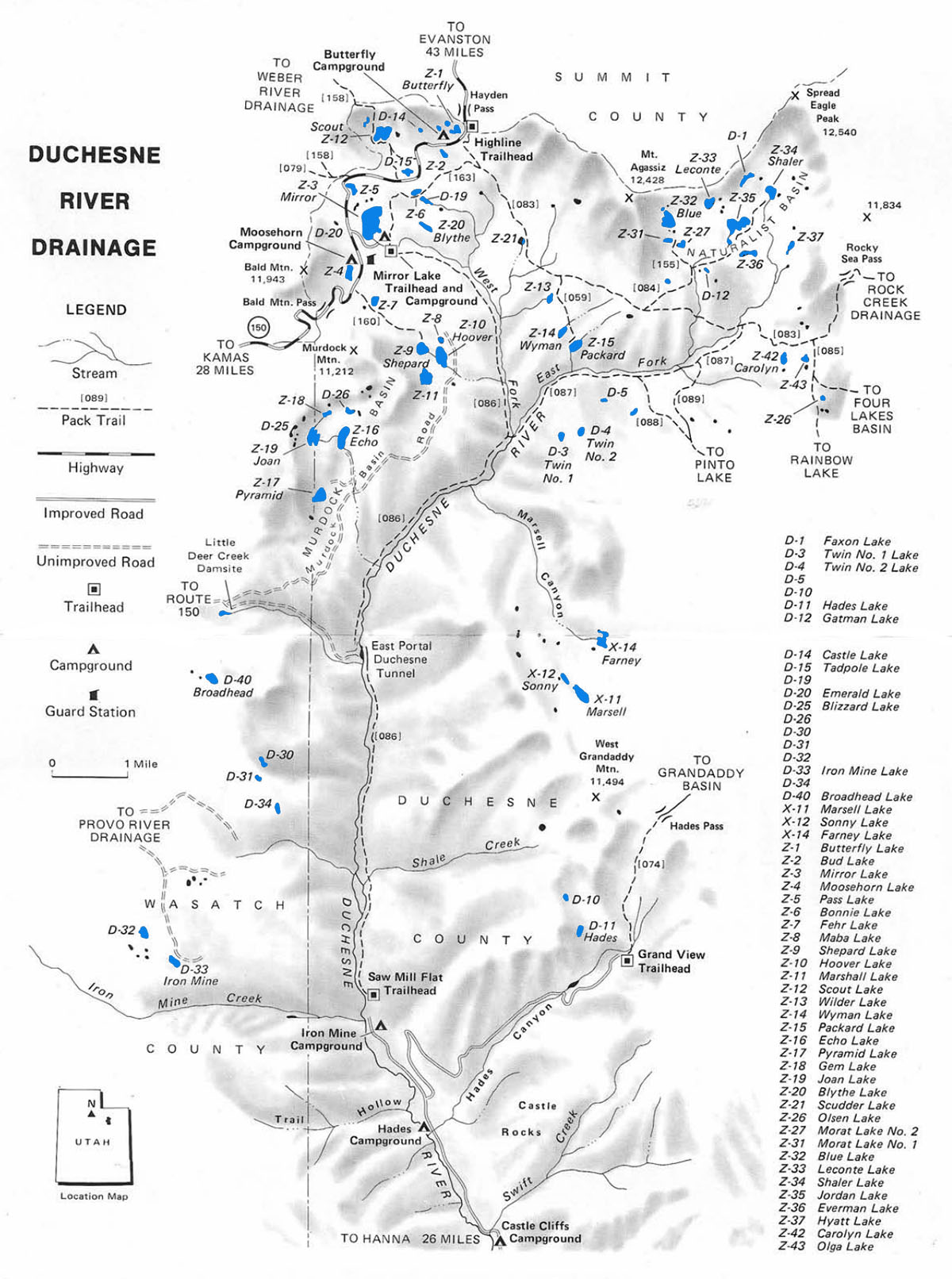
Duchesne River Drainage
The Duchesne River Drainage is one of the more popular areas to fish in the Uinta Mountains. The drainage has 62 natural lakes with over half of these lakes supporting healthy trout populations. This area is also popular among hikers. It is characterized by wide basins with gentle sloping ridges covered with conifers.
The best access for anglers is via U-150 east of Kamas, UT or Hwy 35 just north of the city of Hanna. The drainage can also be accessed using the Murdock Basin and Iron Mine Mountain Timber roads. Another reason for the basin’s popularity is that 15 of the best fishing lakes are directly accessible by vehicle and the remaining lakes can be reached using well-maintained hiking trails.
Most visitors to the Duchesne River Drainage access the area using the Highline and Mirror Lake trailheads just off U-150 or via the Grandview and Sawmill Flat trailheads on Highway 35. The Highline trail is the major inland route providing access to Naturalist Basin and Packard Lake Trail. If you want to access the lakes along the eastern rim of the drainage, such as Sonny, Farney and Marshall, take the Grandaddy Trail from the trailhead.
Lesser traveled access routes into the Duchesne River Drainage include the Olga Lake Trail, East Fork Trail, Skinner Duchesne River Trail, Cutoff Trail, Mirror Lake Trail, Pinto Lake Trail, Blue Lake Trail and Fehr Lake Trail.
The lakes along the Mirror Lake Highway Corridor receive the most fishing pressure of any lakes in the basin. Popularity of these lakes is driven by great fishing and amenities. Moosehorn Lake, Mirror Lake, Butterfly Lakes and Scout Lake offer well-maintained campgrounds, restrooms an picnic facilities. Jordan Lake in the Naturalist Basin recieves the highest fishing pressure and activity. If you’re looking for solitude, it’s recommended to visit of one of the many other basins in the Uintas.
You’ll find both brook trout and cutthroats throughout the drainage, but brookies are by far the more abundant species. Rainbow trout can be found in a few of the larger stocked lakes including Mirror Lake, Moosehorn Lake, Pass Lake and Butterfly Lakes. If you’re interested in hooking an Arctic grayling, hit Carolyn Lake.
| Lake name | Size (acres) | Max depth (ft) | Fish species | Fishing pressure |
|---|---|---|---|---|
| Blizzard, D-25 | 19 | 36 | Brook trout | Moderate |
| Blythe, Z-20 | 5 | 14 | Brook trout (stocked) | Moderate |
| Bonnie, Z-6 | 3.6 | 7 | Brook trout (stocked), Cutthroat | High |
| Broadhead, D-40 | 8.8 | 16 | Brook trout (stocked) | Low |
| Bud, Z-2 | 3.7 | 13 | Brook trout (stocked) | Moderate |
| Butterfly, Z-1 | 4.3 | 13 | Rainbow and brook trout (stocked) | High |
| Carolyn, Z-42 | 5 | 17 | Brook and cutthroat trout | Moderate |
| Castle, D-14 | 1 | 12 | Cutthroat trout, Tiger trout | Moderate |
| D-19 | 1.2 | 6 | Brook and cutthroat trout | Moderate |
| D-26 | 3 | 10 | Brook trout (stocked) | Moderate |
| Echo, Z-16 | 18 | 44 | Golden trout | Moderate |
| Everman, Z-36 | 7.8 | 7 | Brook trout (stocked) | Moderate |
| Farney, X-14 | 12.6 | 14 | Arctic grayling (stocked) | Low |
| Fehr, Z-7 | 5.7 | 27 | Brook trout | High |
| Gem, Z-17 | 3.8 | 14 | Tiger trout | Low |
| Hades, D-11 | 6.4 | 32 | Rainbow and brook trout (stocked) | Low |
| Hoover, Z-10 | 18.6 | 28 | Brook and cutthroat trout | High |
| Joan, Z-19 | 15.2 | 20 | Brook trout | Moderate |
| Jordan, Z-35 | 23.2 | 30 | Brook trout (stocked) | Moderate |
| Leconte, Z-33 | 9.5 | 15 | Cutthroat trout, Arctic grayling | Moderate |
| Maba, Z-8 | 4.2 | 20 | Brook trout | High |
| Marsell, X-11 | 16.4 | 50 | Cutthroat trout (stocked) | Moderate |
| Marshall, Z-11 | 18 | 36 | Cutthroat | High |
| Mirror, Z-3 | 42 | 37 | Rainbow and brook trout (stocked) | High |
| Moosehorn, Z-4 | 8 | 11 | Rainbow trout (stocked) | High |
| Morat #1, Z-31 | 5.4 | 13 | Cutthroat trout (stocked) | Moderate |
| Morat #2, Z-27 | 3.6 | 5 | Cutthroat trout | Moderate |
| Packard, Z-15 | 4.5 | 10 | Brook trout | High |
| Pass, Z-5 | 3.3 | 8 | Rainbow trout | Moderate |
| Pyramid, Z-17 | 15 | 36 | Brook trout | High |
| Scout, Z-12 | 30 | 17 | Rainbow trout | High |
| Shaler, Z-34 | 13 | 7 | Cutthroat trout | Moderate |
| Shepard, Z-9 | 14.2 | 32 | Brook, cutthroat and rainbow trout | High |
| Sonny, X-12 | 5 | 13 | Brook trout (stocked) | Low |
| Wilder, Z-13 | 3.7 | 14 | Brook trout | High |
| Wyman, Z-14 | 6.5 | 17 | Brook trout (stocked) | Moderate |
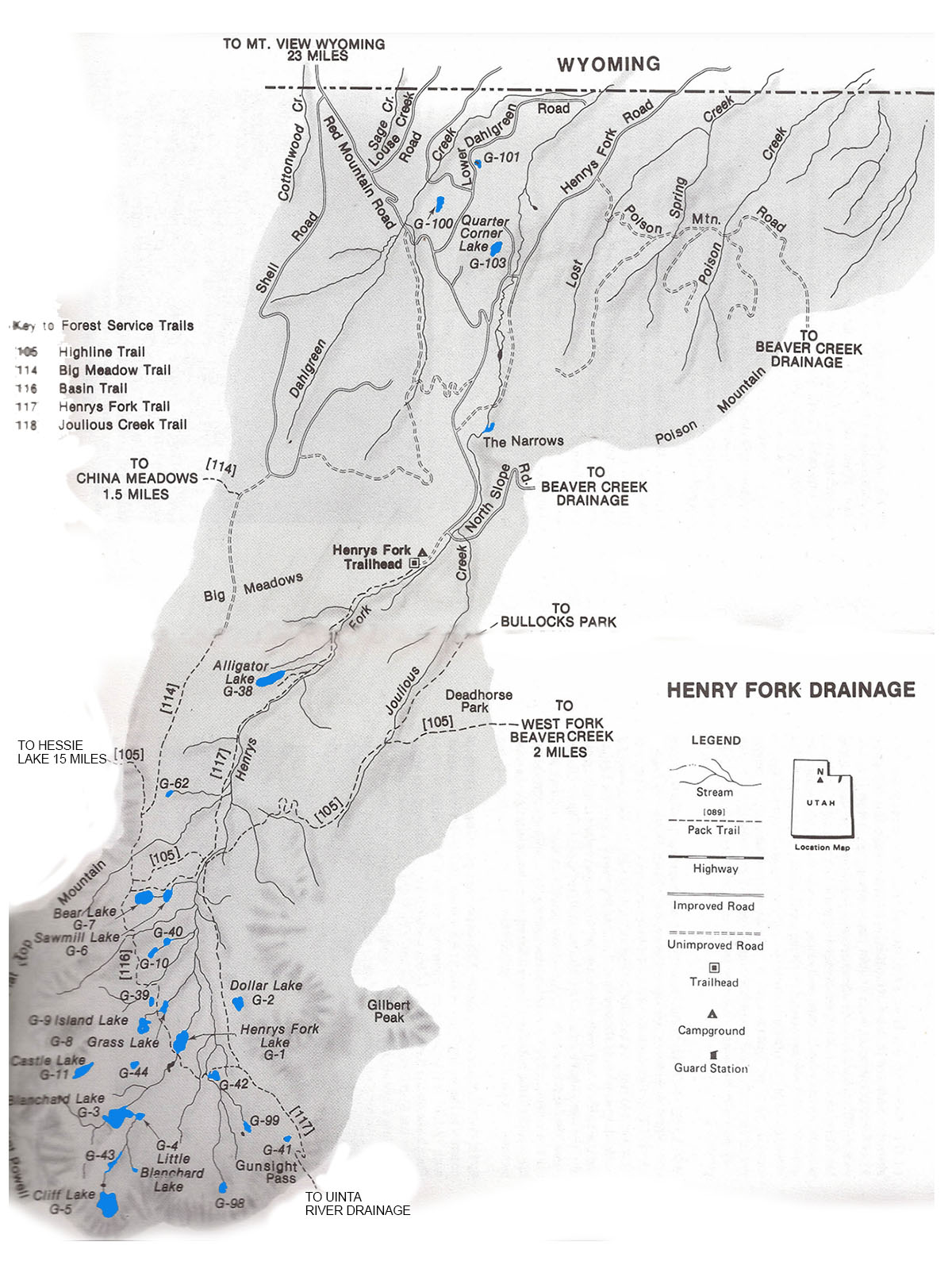
Henrys Fork Drainage
The Henry Forks Drainage is a relative small drainage located 25 miles south of Mountain View, Wyoming on the north slope of the Uinta Mountains. It is charactized by narrow river valleys, wide timbered slopes, sparse alpine tundra, and tundra-covered plateaus.
The drainage has over 50 lakes and several small ponds under an acre in size. About 40% of the lakes in the Henry Fork Drainage have substantial fish populations. About a third of the fishing lakes in the drainage experience fairly high fishing pressure. If you’re looking for more solitude, fish some of the more remote lakes in the basin. Cutthroats are the most popular trout species in Henrys Fork waters, but anglers also report catching brook trout. Many of the lakes in this drainage receive periodic aerial stockings of trout fingerlings.
The drainage is accessible from Mountain View or Lonetree, Wyoming via well-maintained Forest Service roads. The Henry Fork Trail provides access to most of the lakes in the backcountry. This trail begins at the Henry Fork Trailhead and runs south over Gunsight Pass into the Uinta River Drainage. Smiths Fork Drainage to the west and Beaver Creek Drainage to the east also provide access Henrys Fork Drainage via the interbasin Highline Trail. The interbasin Highline Trail (“Basin Trail”) provides access to many of the good fishing lakes along the western end of the Henrys Fork Drainage.
| Lake name | Size (acres) | Max depth (ft) | Fish species | Fishing pressure |
|---|---|---|---|---|
| Alligator, G-38 | 14.5 | 26 | Trout | High |
| Bear, G-7 | 16.9 | 37 | Brook trout (stocked) | Moderate |
| Blanchard, G-3 | 31.3 | 29 | Cutthroat trout | Moderate |
| Castle, G-11 | 11.5 | 10 | Brook trout (stocked) | Low |
| Cliff, G-5 | 33.1 | 69 | Cutthroat trout (stocked), Tiger trout | Low |
| Dollar, G-2 | 9.7 | 18 | Brook and cutthroat trout | Moderate |
| G-10 | 5.4 | 12 | Brook trout | Low |
| G-39 | 2.6 | 7 | Brook trout | Low |
| G-42 | 4.6 | 2 | Brook and cutthroat trout | Low |
| G-44 | 1.5 | 7 | Cutthroat trout | Low |
| G-62 | 2.2 | 7 | Brook trout | Low |
| G-100 | 7.9 | 13 | Brook trout | Low |
| Grass, G-8 | 5.5 | 4 | Brook and cutthroat trout | Moderate |
| Henrys Fork, G-1 | 19.7 | 19 | Cutthroat trout | Moderate |
| Island, G-9 | 10.4 | 5 | Brook trout (stocked) | Low |
| Little Blanchard, G-4 | 3.6 | 8 | Cutthroat trout | Low |
| Sawmill, G-6 | 7.2 | 21 | Brook and cutthroat trout | High |
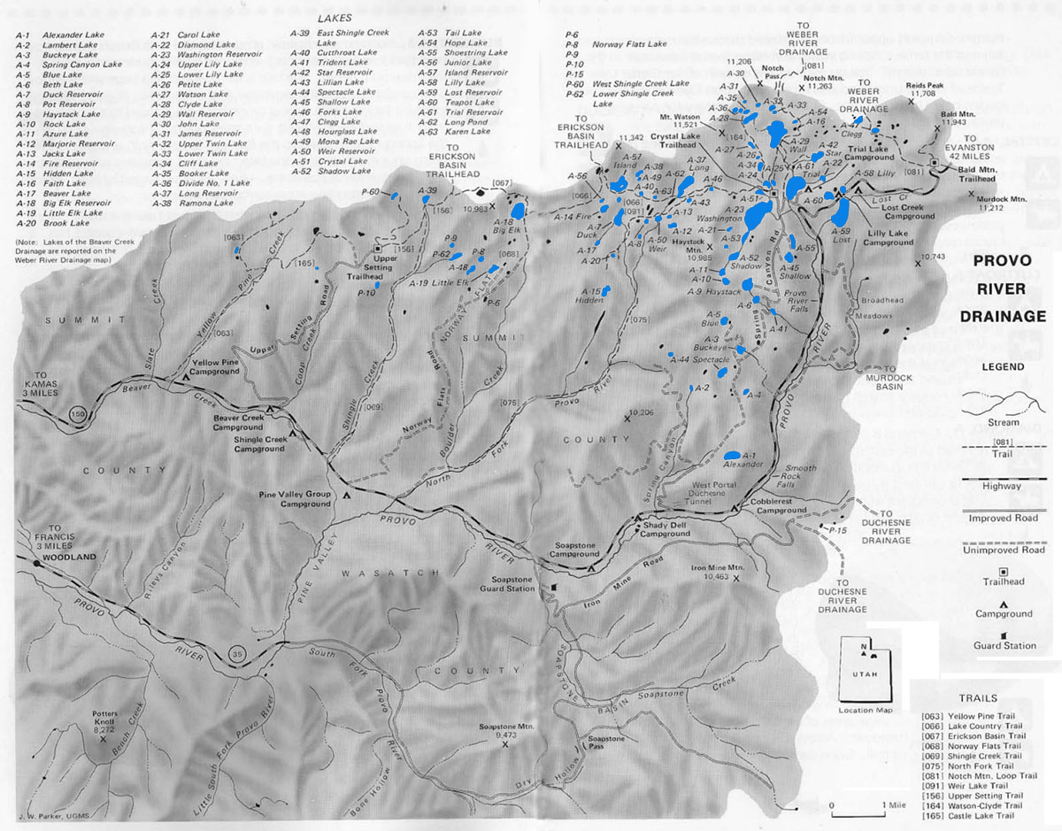
Provo River Drainage
The Provo River Drainage along the western end of the Uinta Mountain Range is characterized by wide drainage basins, dome-like mountain peaks and timbered ridges. There about 80 lakes and 150 smaller (2 acre) ponds located in the drainage. About 70% of the lakes in the Provo River Drainage offer productive fishing. The majority of lakes are located north west of Mirror Lake Highway (U-150) beginning near the city of Kamas, Utah.
Most fishing in the Provo Drainage occurs along the Mirror Lake Highway corridor. Trail, Lily and Lost lakes are three of the most popular camping lakes and have heavy fishing pressure. Lakes along the popular Lakes Country Trail also experience high fishing pressures. For solitude you’re required to fish the remote lake basins an backcountry waters away from high traffic roads and trails.
The Crystal Lake Trailhead provides the main access to the most of the fishable backcountry lakes in the basin. Other access trails within the vecinity include Lake Country Trail, Notch Mountain Loop Trail, and Watson-Clyde Trail. The Watson-Clyde Trail is a bit challenging to locate and navigate. It begins at the northwestern end of Uppler Lily Lake near the Crystal Lake Trailhead. Other important access points for the Provo River Drainage include the Upper Setting and Bald Mountain trailheads which provide access to the Weber Basin lakes.
Together Mirror Lake Highway (U-150) and Forest Service Roads including Norway Flats Road, Spring Caynon Road, and Upper Setting Road provide access to the majority of the Provo River Drainage. Several (20) of the lakes in the drainage are directly accessible by vehicle and many more are accessible within a short walking distance from the road.
Brook trout are by far the most abundant gamefish in the Provo River Drainage and are found in most of the fishable lakes. Stocked cutthroats are also found throughout the drainage. A few of the more popular lakes adjacent to Mirror Lake Highway are stocked with rainbow trout. If you’re interested in Arctic grayling, fish Weir and Marjories lakes.
| Lake name | Size (acres) | Max depth (ft) | Fish species | Fishing pressure |
|---|---|---|---|---|
| Alexander, A-1 | 23 | 28 | Brook trout (stocked) | High |
| Azure, A-11 | 9 | 23 | Arctic grayling | Low |
| Beaver, A-17 | 3.5 | 15 | Brook trout (stocked) | Low |
| Beth, A-6 | 5.4 | 10 | Brook trout | High |
| Big Elk, A-18 | 30 | 85 | Brook and tiger trout | High |
| Blue, A-5 | 8 | 26 | Brook trout (stocked) | High |
| Booker, A-35 | 4.1 | 8 | Brook trout | High |
| Brook, A-20 | 1.1 | 6 | Brook trout | Moderate |
| Buckeye, A-3 | 5 | 8 | Brook trout (stocked) | High |
| Clegg, A-47 | 5.1 | 12 | Brook trout (stocked) | Moderate |
| Cliff, A-34 | 9 | 20 | Cutthroat and tiger trout | High |
| Clyde, A-28 | 16 | 21 | Brook trout | High |
| Crystal, A-51 | 9.8 | 7 | Brook trout (stocked) | High |
| Cutthroat (Clint), A-40 | 3 | 10 | Brook and tiger trout | Low |
| Diamond, A-22 | 3 | 7 | Brook and cutthroat trout | Moderate |
| Divide, #1, A-36 | 3.5 | 5 | Brook trout | High |
| Duck, A-7 | 12.7 | 15 | Brook and cutthroat trout | High |
| Fire, A-14 | 9 | 59 | Cutthroat trout | Moderate |
| Haystack, A-9 | 17 | 29 | Brook and cutthroat trout | High |
| Hidden, A-15 | 8.2 | 25 | Brook trout (stocked) | Moderate |
| Hope, A-54 | 2 | 5 | Brook trout | Low |
| Hourglass, A-48 | 5.7 | 2 | Brook and cutthroat trout | High |
| Island, A-57 | 28 | 40 | Brook, cutthroat and tiger trout | High |
| Jacks, A-13 | 1.2 | 23 | Brook trout | Moderate |
| James, A-31 | 2.1 | 8 | Brook trout (stocked) | Moderate |
| John, A-30 | 4 | 10 | Brook trout | Moderate |
| Junior, A-56 | 2.8 | 11 | Cutthroat and tiger trout | Low |
| Lambert A-2 | 2 | 8 | Brook trout (stocked) | Low |
| Lillian, A43 | 2 | 8 | Brook trout | Low |
| Lilly, A-58 | 4.1 | 13 | Rainbow trout | Moderate |
| Lily, Lower, A-25 | 3.2 | 16 | Brook trout | High |
| Little Elk, A-19 | 13.2 | 31 | Cutthroat trout | Moderate |
| Long Pond, A-62 | 2 | 5 | Brook and cutthroat trout | Moderate |
| Long, A-37 | 35 | 26 | Brook and cutthroat trout | High |
| Lost, A-59 | 62 | 22 | Rainbow trout (stocked) | Moderate |
| Marjorie, A-12 | 13 | 16 | Arctic grayling | High |
| Petit (Junior #5), A-26 | 2 | 3 | Brook trout | Moderate |
| Pot, A-8 | 4 | 28 | Brook trout (stocked) | High |
| Ramona, A-38 | 4.7 | 21 | Brook trout (stocked) | Moderate |
| Rock, A-10 | 8 | 14 | Tiger trout | Moderate |
| Shadow, A-52 | 14 | 20 | Brook trout | High |
| Shingle Creek, East, A-39 | 7 | 44 | Brook and tiger trout | High |
| Shingle Creek, Lower, P-62 | 4 | 14 | Brook trout | Moderate |
| Shingle Creek, West, P-60 | 5 | 12 | Brook trout (stocked) | Moderate |
| Spectacle (Hourglass), A-44 | 9.3 | 17 | Brook trout (stocked) | Moderate |
| Star, A-42 | 16 | 35 | Brook and tiger trout | High |
| Tail, A-53 | 9.8 | 13 | Brook, cutthroat and rainbow trout | High |
| Teapot, A-60 | 13 | 46 | Rainbow and brook trout | High |
| Trial, A-61 | 98 | 68 | Rainbow and brook trout | High |
| Trident, A-41 | 4 | 5 | Brook trout | High |
| Twin, Lower, A-33 | 3 | 14 | Brook trout | High |
| Twin, Upper, A-32 | 9 | 13 | Brook and tiger trout | High |
| Wall, A-29 | 80 | 97 | Brook and tiger trout | High |
| Washington, A-23 | 106 | 70 | Rainbow, cutthroat and brook trout | High |
| Watson, A-27 | 6 | 10 | Brook trout | Moderate |
| Weir, A-50 | 7 | 13 | Cutthroat and arctic grayling | Moderate |
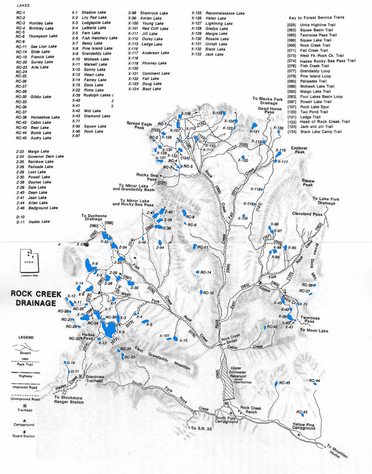
Rock Creek Drainage
Rock Creek is one of the larger drainages in the Uinta Mountains. It is composed of several smaller drainage systems including the Squaw Basin, Central Basin, and Grandaddy Basin.
The major rivers in the Squaw Basin are the Squaw Basin Creek and East Fork of Rock Creek. The Central Basin is drained by Mainstream Rock Creek and Fall Creek. Rivers in the more popular Grandaddy Basin include Fish Creek and the West Fork of Rock Creek. A small forth basin, due south of Grandaddy Mountain, is drained by the South Fork of Rock Creek.
There are over 120 lakes and ponds located within the Rock Creek Drainage. Good fishing and panoramic views of rolling tundra and scenic timber landscapes draw anglers, hikers and adventure seekers to the drainage. Angling pressure in the Rock Creek Drainage is light to moderate at most fishable lakes.
Visitors can access the Rock Creek Drainage at the trailhead of Upper Stillwater. A main trail runs along Rock Creek up the central drainage basin. Trails split off the main trail following (1) the West Fork of Rock Creek and Fish Creek to Grandaddy Basin, (2) the East Fork of Rock Creek and Squaw Basin Creek to Squaw Basin and Rudolph Lake, and (3) Fall Creek to the eastern region of central basin. Grandaddy Basin can also be accessed from the Grandview transfer in Hades Canyon.
Fishing pressure and recreational activity is high in the Grandaddy Basin, Squaw Basin and Black Lake areas—with recreational use highest in the Grandaddy Basin. Lakes in the Rock Creek Drainage are home to populations of reproducing and stocked cutthroat and brook trout.
| Lake name | Size (acres) | Max depth (ft) | Fish species | Fishing pressure |
|---|---|---|---|---|
| Allen, Z-44 | 15.2 | 16 | Brook trout (natural reproducing), Arctic grayling | Low |
| Amlen, X-99 | 7.3 | 9 | Brook trout (stocked) | Moderate |
| Anderson, X-117 | 5.8 | 12 | Brook trout (natural reproducing), cutthroat trout | High |
| Arta, RC-23 | 5.4 | 6 | Cutthroat trout | Low |
| Audrey, RC-45 | 13.2 | 25 | Brook trout (stocked) | Low |
| Bedground, Z-46 | 2 | 15 | Brook trout (stocked), Arctic grayling | Moderate |
| Betsey, X-7 | 33.8 | 44 | Cutthroat and brook trout | High |
| Black, X-132 | 11.8 | 14 | Brook trout (stocked) and cutthroat | High |
| Boot, X-124 | 9.1 | 17 | Cutthroat trout | Low |
| Brinkley, RC-4 | 4.2 | 18 | Brook trout | High |
| Cabin, RC-42 | 4.3 | 16 | Brook trout (stocked) | Low |
| Continent, X-121 | 27.4 | 23 | Cutthroat and brook trout | Moderate |
| Dale, Z-39 | 12.9 | 25 | Brook trout (stocked) | High |
| Daynes, Z-38 | 23.2 | 21 | Brook trout (stocked) and arctic grayling | |
| Dean, Z-40 | 24 | 44 | Brook trout (stocked) | Moderate |
| Diamond, X-43 | 13 | 45 | Brook trout (stocked) | Moderate |
| DOC'S, X-15 | 14.5 | 45 | Brook trout (stocked) | Low |
| Doug, X-123 | 1 | 8 | Cutthroat (natural reproducing) | Low |
| Fern, X-5 | 19.3 | 19 | Brook trout (stocked) | Moderate |
| Fish Hatchery, X-6 | 37.2 | 28 | Brook trout | High |
| Gibby, RC-30 | 1.9 | 25 | Brook trout (stocked) | Moderate |
| Gladys, X-128 | 7.5 | 6 | Brook trout (stocked) | Moderate |
| Governor Dern, Z-24 | 32 | 9 | Brook and cutthroat trout | High |
| Grandaddy, X-9 | 173 | 40 | Brook and cutthroat trout (naturally reproducing) | High |
| Heart, X-13 | 5.7 | 19 | Cutthroat trout (stocked) | High |
| Helen, X-126 | 8.4 | 14 | Brook trout (stocked) | Moderate |
| Horseshoe, RC-38 | 2.9 | 20 | Brook trout (stocked) | Low |
| Huntley, RC-3 | 1.2 | 9 | Brook trout (naturally reproducting) | Low |
| Jack, X-133 | 2.7 | 14 | Cutthroat and brook trout | Moderate |
| Jean, Z-41 | 23.2 | 23 | Brook and cutthroat trout | Moderate |
| Jill, X-111 | 3.6 | 25 | Brook trout (stocked) | Moderate |
| Ledge, X-113 | 3.1 | 13 | Brook trout (stocked) | Moderate |
| Lightning, X-127 | 14.1 | 23 | Brook and cutthroat trout | Moderate |
| Lily Pad, X-2 | 9.5 | 14 | Brook and cutthroat trout | Moderate |
| Lodgepole, X-3 | 20.4 | 29 | Brook trout (stocked) | Moderate |
| Lost, Z-29 | 14 | 15 | Brook trout (stocked) | Moderate |
| Margie, X-129 | 7.5 | 11 | Brook trout (stocked) | Low |
| Margo, Z-23 | 11.1 | 29 | Cutthroat trout (stocked) | Low |
| MID, X-42 | 5.1 | 3 | Brook trout (stocked) | Moderate |
| Mohawk, X-10 | 50.8 | 23 | Brook trout (naturally reproducting) | High |
| Ouray, X-112 | 4 | 6 | Cutthroat and brook trout | Moderate |
| Palisade, Z-28 | 22.7 | 45 | Brook and cutthroat trout | High |
| Phinney, X-119 | 13.6 | 30 | Brook trout (stocked) | Moderate |
| Pine Island, X-8 | 79.6 | 44 | Brook trout (stocked) | High |
| Pinto, X-22 | 46.6 | 36 | Brook trout (stocked) | High |
| Powell, Z-30 | 22.4 | 15 | Cutthroat trout (stocked) | Moderate |
| Rainbow, Z-25 | 17.9 | 15 | Brook trout (stocked) | High |
| Reconnaissance, X-125 | 8.8 | 30 | Brook and cutthroat trout (naturally reproducing) | Low |
| Rock1, X-96 | 4.8 | 19 | Brook trout | Low |
| Rock 2, X-97 | 7.7 | 17 | Brook trout (stocked) | Low |
| Rosalie, X-130 | 8.1 | 8 | Brook trout (stocked) | Low |
| Rudolph 1, X-39 | 25.6 | 46 | Brook trout (stocked) | Moderate |
| Rudolph 2, X-40 | 2.9 | 9 | Brook trout (stocked) | Moderate |
| Rudolph 3, X-41 | 2.4 | 14.5 | Brook trout | Low |
| Sea Lion, RC-11 | 7.9 | 11 | Cutthroat trout (stocked) | Low |
| Shadow, X-1 | 7.2 | 22 | Brook and cutthroat trout | Moderate |
| Shamrock, X-98 | 18.2 | 33 | Brook trout (stocked) | Moderate |
| Squaw, X-95 | 10.4 | 9 | Brook trout (stocked) | High |
| Survey, RC-20 | 6 | 12 | Brook trout (stocked) | Low |
| Thompson, RC-8 | 21.2 | 26 | Brook trout (stocked) | Low |
| Uintah, X-131 | 8.4 | 14 | Brook trout (stocked) | Low |
| Youg, X-100 | 4 | 19 | Cutthroat trout (stocked) | Low |
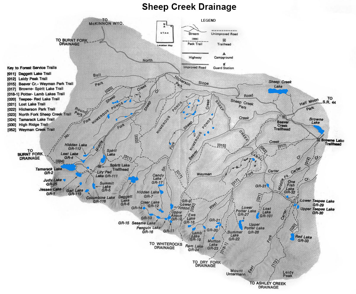
Sheep Creek/Carter Creek Drainage
Sheep Creek and Carter Creek drainages are located on the north slope of the Uinta Mountain Range. These two drainages are often referred to as the Sheep/Carter Creek Drainage since they geographically are just one drainage system.
The Sheep/Carter Creek Drainage has over 60 lakes. Four of the more popular fishing lakes, Sheep Creek Lake, Browne Lake, Long Park Reservoir, and Spirit lake can be accessed by vehicle. About half of the lakes in the Sheep/Carter Creek Drainage provide abundant trout populations. In additional to 60 larger lakes, the drainage also supports nearly 300 smaller ponds and waterways.
There are a few access points to The Sheep/Carter Creek Drainage. A well-maintained dirt road accessible from Utah SR 44 provides direct access to trail heads at Browne Lake and Spirit Lake. The trail heads at Browne Lake in turn provide access to lakes in the Teepee Lakes area, Weyman Lakes Basin, and Lamb Lakes Basin. The trail heads originating at Spirit Lake lead to Daggett Lake, Weyman Lakes Basin, the Jesson/Tamarack lakes area, as well as several lakes at the eastern end of the Burnt Fork Drainage.
Lakes with the highest fishing pressure include Daggett Lake, the Jesson/Tamarack Lakes, and Teepee Lakes. These lakes are also the most accessible. Fishing pressure to Weyman Lakes Basin is moderate, and you’ll find the lowest fishing pressure in the Lamb Lakes Basin. Lakes locate further from trailheads typically receive the least amount of fishing pressure.
Brook trout are the most abundant game fish found in the lakes within the Sheep/Carter Creek Drainage. Cutthroat are present but in fewer numbers than Brook trout. A few lakes contain rainbow trout and graylings.
| Lake name | Size (acres) | Max depth (ft) | Fish species | Fishing pressure |
|---|---|---|---|---|
| Anson, Lower GR-9 | 14.5 | 20 | Brook and cutthroat trout | Moderate |
| Anson, Upper, GR-10 | 7.7 | 58 | Brook trout (natural reproducing) | Moderate |
| Bummer, GR-22 | 1.9 | 6 | Brook trout, Arctic grayling | Low |
| Clear, GR-12 | 10.2 | 25 | Cutthroat trout, Tiger trout | Low |
| Columbine, GR-116 | 5.7 | 5 | Brook trout (stocked), Tiger trout | Low |
| Daggett, GR-6 | 42.6 | 29 | Rainbow trout (stocked), Tiger trout | High |
| EWE, GR-18 | 3 | 10 | Arctic grayling | Low |
| Gail, GR-115 | 4.5 | 25 | Cutthroat trout | Low |
| GR-11 | 2.6 | 8 | Brook trout (stocked) | Low |
| GR-13 | 9.2 | Unknown | Brook trout (stocked) | Low |
| GR-20 | 5.7 | 8 | Brook trout (stocked) | Low |
| GR-21 | 3.7 | 7 | Brook trout (stocked) | Low |
| GR-31 | 6 | 6 | Brook trout (naturally reproducing) | Low |
| GR-104 | 4.3 | 19 | Trout | Low |
| Hidden, GR-7 | 8.5 | 26 | Brook (stocked) and cutthroat trout | Low |
| Hidden, GR-112 | 4.3 | 8 | Brook and cutthroat trout | Low |
| Jesson, GR-1 | 25.5 | 56 | Brook (stocked) and cutthroat trout, Tiger trout | High |
| Judy, GR-25 | 4.7 | 24 | Brook trout (stocked), Tiger trout | Low |
| Lamb, GR-19 | 6 | 10 | Arctic grayling, Tiger Trout | Low |
| Lost, GR-4 | 3.2 | 7 | Cutthroat trout (naturally reproducing) | Low |
| Lost, GR-101 (Mystery) | 10.2 | 25 | Brook (stocked) and cutthroat trout | Moderate |
| Mutton, GR-23 | 3.8 | 10 | Brook trout (stocked) | Low |
| One Fish, GR-32 | 4.5 | 35 | Brook trout (stocked), Arctic grayling | Low |
| Penguin, GR-16 | 2.1 | 20 | Brook trout (naturally reproducing) | Moderate |
| Potter, Lower, GR-27 | 3.4 | 16 | Brook trout (naturally reproducing) | Moderate |
| Potter, Upper, GR-27 | 21.3 | 75 | Brook trout (naturally reproducing) | Low |
| RAM, GR-24 | 7 | 27 | Cutthroat trout | Low |
| RED, GR-33 | 20.9 | 57 | Brook trout (stocked), Tiger trout | Low |
| Sesame, GR-15 | 6 | 7 | Brook trout (stocked), Arctic grayling | Low |
| Summit, GR-5 | 9.9 | 7 | Arctic grayling | Low |
| Tamarack, GR-2 | 79.1 | 90 | Brook trout and cutthroat trout (naturally reproducing), Tiger Trout | High |
| Teepee, Lower, GR-28 | 4.3 | 28 | Brook trout (stocked) | High |
| Teepee, Upper, GR-30 | 6.5 | 28 | Cutthroat, Tiger trout | Moderate |
Burnt Fork Drainages
The Burnt Fork Drainage is located south of Hoop Lake directly west of the Sheep/Carter Creek Drainage in the northern Uintas. This is a relatively small drainage with only 15 sizable lakes and 100 smaller ponds under 2 acres in size. All but a few of the lakes support trout populations.
There is a dirt road from Lonetree, Wyoming that provides direct access to the Burnt Fork drainage. The road runs south to Hoop Lake which is the main access point for the drainage. The Burnt Fork drainage can also be access on its east end from Spirit Lake (in the Sheep/Carter drainage). The most popular lakes in the drainage are found in the Kabell Lake and Island Lakes region. The Island Lakes region also provides access to the Upper Uinta drainage by way of a pass over the Uinta divide.
The most abundant fish species in the Burnt Fork drainage is cutthroat trout. Many of the lakes also contain brook trout. Over half of the lakes contain both species.
| Lake name | Size (acres) | Max depth (ft) | Fish species | Fishing pressure |
|---|---|---|---|---|
| Bennion, Lower, GR-134 | 7.7 | 13 | Brook and cutthroat trout | Low |
| Bennion, Upper, GR-135 | 2 | 3 | Brook and cutthroat trout | Low |
| Boxer, GR-126 | 6 | 11 | Cutthroat trout | Moderate |
| Burnt Fork, GR-127 | 9.8 | 25 | Cutthroat trout (naturally reproducing) | Moderate |
| Crystal, GR-128 | 5.4 | 5 | Cutthroat trout (naturally reproducing) and brook trout | Low |
| Fish, GR-125 | 38.3 | 23 | Brook and cutthroat trout | Moderate |
| Island, GR-132 | 117.8 | 34 | Cutthroat trout (naturally reproducing) and brook trout | High |
| Kabell, GR-140 | 14.7 | 23 | Cutthroat trout (stocked) | Moderate |
| Round, GR-131 | 24.3 | 38 | Cutthroat trout (stocked) | Moderate |
| Snow, GR-130 | 9.4 | 35 | Cutthroat trout (stocked) | Low |
| Whitewall, GR-133 | 14.5 | 3 | Brook and cutthroat trout | Low |
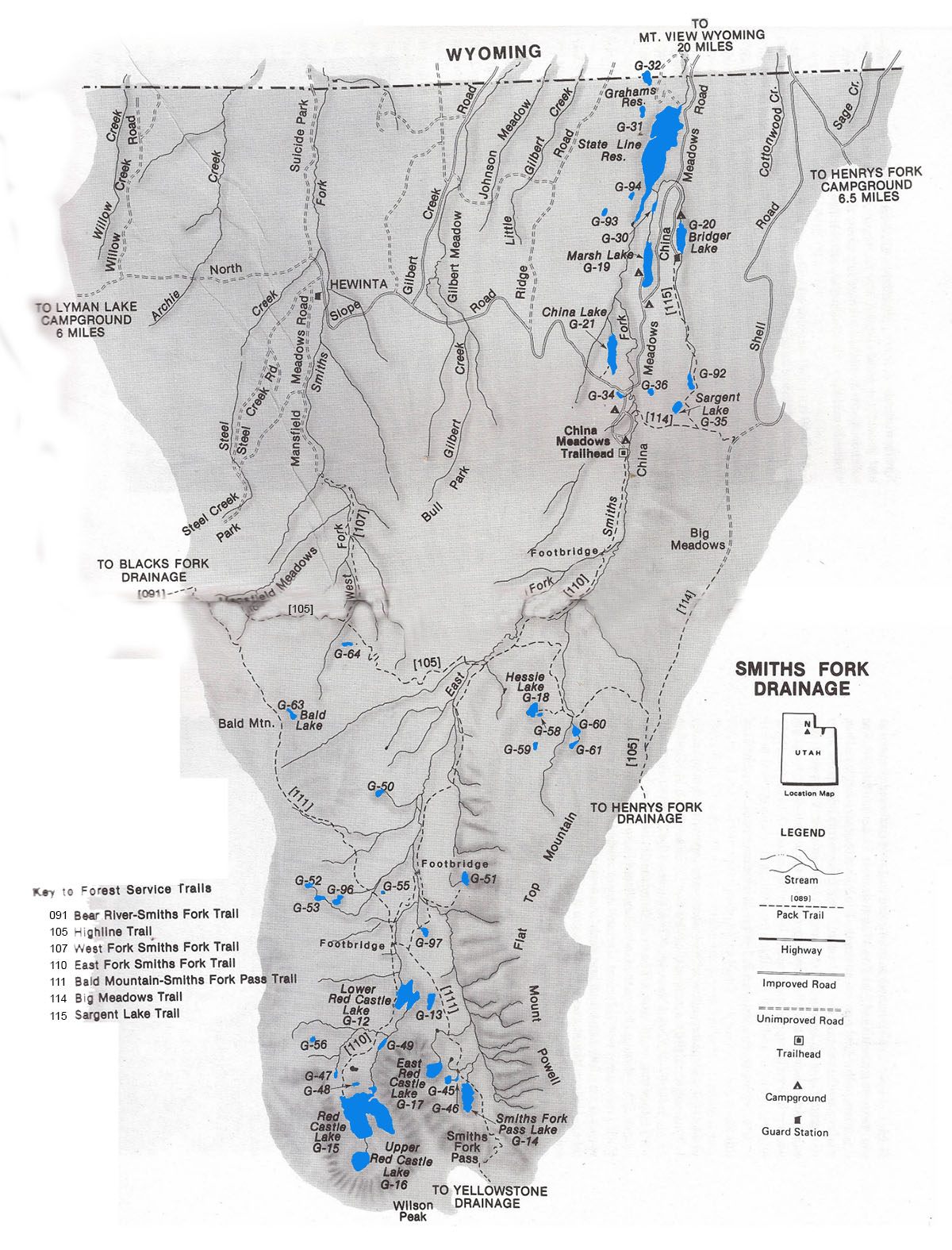
Smiths Fork Drainage
The Smith Fork Drainage is situated near the center of the Uinta Mountains Range. It is characterized by narrow river valleys, sloping timbered plateaus and glacial cirques. Many visitors comment that it is one of the most beautiful of all basins within the Uintas.
The Smith Fork Drainage comprises two smaller drainages: West Fork Drainage and East Fork Drainage. The East Fork Drainage contains the majority of fishable lakes and waterways. In total, there are over 60 lakes, reservoirs and ponds in the East Fork Drainage alone. Many of these lakes contain fishable trout populations.
The most common gamefish found in the lakes and ponds of the Smiths Fork Drainage are brook and cutthroat trout. Many trout populations are naturally reproducing. Lakes with few natural trout populations receive periodic aerial stockings of fingerlings. Rainbow trout and graylings are also stocked in several of the lakes including Lower Red Castle, China and the more popular Bridger and Marsh Lakes.
Smiths Fork Drainage is accessible from Highway 410 and China Meadows Forest Service Road. It is also accessible from the North Slope Road east of Highway U-150. A few of the fishable lakes in the region are accessible by vehicle, but most are only accessible by trail.
Trails providing access to the wilderness areas of the drainage include (1) East Fork Smiths Fork Trail and (2) the West Fork Smiths Fork Trail. The East Fork Smiths Fork Trail is accessed at the China Meadows Trailhead. The West Fork Smiths Fork Trail is accessed at where the Mansfield Meadows Road ends. From the Black Fork Drainage, the Smith Fork Drainage can be accessed at the Cache Trailhead or from the Yellowstone Drainage at the Bald Mountain Smiths Fork Pass Trail. The lower portion of the drainage can be access via the interbais Highlinee Trail, Sargent Lae Trail and Big Meadows Trail.
Most of the fishable lakes and ponds in the Smith Fork Drainage receive light to moderate fishing pressure. Heaviest fishing pressure occurs at lakes that are most accessible including Marsh Lake, Bridger Lake and China Meadows Lake. You’ll find moderate fishing pressure at Red Castle, Lower Red Castle, and Hessie Lakes.
| Lake name | Size (acres) | Max depth (ft) | Fish species | Fishing pressure |
|---|---|---|---|---|
| Bald, G-63 | 6.4 | 23 | Brook trout (naturally reproducing) | Low |
| Bridger, G-20 | 21 | 15 | Rainbow and brook trout (stocked) | High |
| China, G-21 | 31.2 | 45 | Brook trout, cutthroat trout, arctic grayling | Moderate |
| G-13 | 7.9 | 17 | Brook trout (stocked) | Low |
| G-34 | 1 | 6 | Brook and rainbow trout | Moderate |
| G-36 | 4.7 | 11 | Trout | Low |
| G-45 | 3.1 | 12 | Brook trout (stocked) | Low |
| G-49 | 3.9 | 11 | Brook, cutthroat and rainbow trout | Low |
| G-50 | 3.7 | 5 | Brook trout (naturally reproducing) | Moderate |
| G-51 | 8.1 | 5 | Brook trout | Low |
| G-52 | 2.6 | 4 | Cutthroat (stocked) | Low |
| G-53 | 5.5 | 17 | Cutthroat and brook trout (naturally reproducing) | Moderate |
| G-56 | 1.5 | 12 | Brook trout | Low |
| G-58 | 1.3 | 5 | Cutthroat | Low |
| G-59 | 3.2 | 24 | Brook trout (stocked) | Low |
| G-60 | 2.5 | 9 | Brook trout, Tiger trout | Moderate |
| G-61 | 3.1 | 6 | Brook trout | Low |
| G-64 | 3.4 | 5 | Cutthroat trout (stocked), Tiger trout | Low |
| Grahams, G-32 | 18.5 | 25 | Unknown | Unknown |
| Hessie, G-18 | 13.2 | 18 | Cutthroat trout (stocked), Tiger trout | Moderate |
| Marsh, G-19 | 33.6 | 35 | Brook and rainbow trout (stocked) | High |
| Red Castle, G-15 | 168.2 | 103 | Cutthroat trout (stocked), Tiger trout | High |
| Red Castle, East, G-17 | 21.1 | 58 | Cutthroat trout, Tiger trout | Moderate |
| Red Castle, Lower, G-12 | 45 | 28 | Brook trout | Moderate |
| Red Castle, Upper, G-16 | 25.6 | 72 | Cutthroat (stocked), Tiger trout | Moderate |
| Sargent, G-35 | 8.3 | 22 | Trout | Low |
| Smiths Fork Pass, G-14 | 26.1 | 17 | Cutthroat trout, Tiger trout | Low |
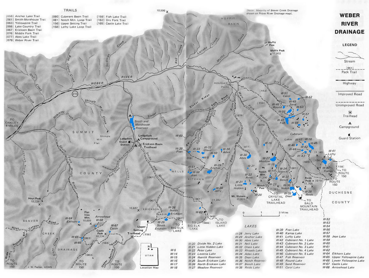
Weber River Drainage
The Weber River Drainage is located at the western end of the Uinta Mountain Range. There are roughly 60 lakes and 100 smaller ponds in the drainage. The area is characterized by timbered slopes and talus ridges.
The easiest way to access the Weber River Drainage is off Hwy 213 just east of the city of Oakley or Hwy U-150 just east of Kamas. Access points along Hwy 213 include the Erickson Basin Trailhead located near the Ledgefork Campground. There are also a couple good trails into the drainage that can be accessed along the Forest Service right-of-way road at Holiday Park. Much of the area around Holiday Park is privately own, so be curteous to property owners.
Some of the best access points to fishable lakes in the Weber River Drainage are accessed via the Upper Setting, Bald Mountain, Crystal Lake, and Weber River trailheads along U-150. These trails drop over the top into the drainage.
There are several lakes in the Weber River Drainage that are more remote and inaccessible. These lakes can be accessed via the Lofty Lake Loop Trail, Notch Mountain Loop Trail, Yellowpine Trail, and Smith-Morehouse Trail. When exploring the backcountry lakes in the Weber River Drainage makes sure to accurately map your course before arriving.
About sixty percent of the lakes in the Weber River Drainage have fishable populations of trout. Brook trout are the most likely catch, but cutthroat are also present. Fishing pressure for the lakes and ponds in the Weber Basin is light to moderate.
The best trout fishing lakes—and those with the heaviest fishing pressure—include Cuberant #4, Abes, Fish, Erickson, Dean, North, Round, Notch, Yellowpine, and Sand Lakes. If you’re seeking solitude, fish elsewhere. If you want to try your hand at catching some Arctic grayling, fish Round and Sandy Lakes. You’ll also find good trout fishing in some of the more remote streams throughout the drainage.
| Lake name | Size (acres) | Max depth (ft) | Fish species | Fishing pressure |
|---|---|---|---|---|
| Abes, W-30 | 21.6 | 62 | Cutthroat trout | High |
| Adax, W-34 | 5 | 10 | Cutthroat trout | Low |
| Anchor, W-29 | 13 | 50 | Brook trout | Moderate |
| Arrowhead, W-68 | 2.1 | 26 | Brook trout (naturally reproducing) | Moderate |
| Carol, W-51 | 3 | 25 | Brook trout (stocked) | Low |
| Castle, W-67 | 10 | 30 | Tiger trout | Moderate |
| Cuberant #1, W42 | 3.5 | 18 | Brook trout | Moderate |
| Cuberant #2, W43 | 3.2 | 6 | Brook and cutthroat trout | Moderate |
| Cuberant #3, W44 | 3.5 | 24 | Brook trout | Moderate |
| Cuberant #4, W45 | 22 | 25 | Tiger trout | Moderate |
| Cuberant #5, W46 | 5 | 15 | Unknown | Low |
| Dean, W-35 | 12 | 16 | Brook trout, Arctic grayling | High |
| Divide #2, W-20 | 3.5 | 10 | Trout | Low |
| Elkhorn, W-64 | 1.5 | 10 | Brook trout (stocked) | Moderate |
| Erickson, South, W-25 | 10 | 12 | Brook trout (stocked) | Moderate |
| Erickson, North, W-26 | 9 | 12 | Brook trout (stocked) | High |
| Fish, W-47 | 46 | 38 | Arctic grayling, brook trout | High |
| Fran, W-39 | 3 | 8 | Brook trout | Moderate |
| Ibantik, W-24 | 10.2 | 28 | Brook trout (naturally reproducing) | High |
| Jean, W-58 | 3 | 25 | Cutthroat trout (stocked) | Low |
| Jerry, W-28 | 3.2 | 16 | Brook trout (stocked) | Low |
| Kamas, W-40 | 17.1 | 42 | Tiger trout | Moderate |
| Little Hidden, W-21 | 8 | 28 | Brook trout | Moderate |
| Lofty, W41 | 4 | 20 | Tiger trout | Moderate |
| Lovenia, W-23 | 2.5 | 11 | Brook trout | High |
| Meadow, W-27 | 29 | 46 | Cutthroat trout (naturally reproducing), Tiger trout | High |
| Neil, W-31 | 1.1 | 20 | Brook trout | Low |
| Notch, W-36 | 20.2 | 57 | Brook and cutthroat trout | Moderate |
| Olsen, W-32 | 7 | 13 | Brook trout (stocked) | Moderate |
| Peter, W-22 | 3 | 13 | Unknown | Low |
| Reids, W-38 | 3 | 8 | Brook trout | Low |
| Rhoads, W-33 | 7.5 | 32 | Brook trout (naturally reproducing) | Moderate |
| Round, W-48 | 5 | 36 | Cutthroat trout, Arctic grayling | Moderate |
| Sand, W-49 | 19.3 | 41 | Arctic grayling | Low |
| W-16 | Unknown | Unknown | Brook trout (stocked) | Low |
| W-52 | 3.6 | 25 | Brook trout | Moderate |
| W-53 | 2.2 | 9 | Brook trout (stocked) | Low |
| W-57 | 3 | 8 | Brook trout (stocked) | Moderate |
| W-59 | 4 | 10 | Brook trout (naturally reproducing) | Moderate |
| W-62 | 2.1 | 18 | Brook trout (stocked) | Low |
| Yellowpine, Lower, W-66 | 2 | 7 | Brook trout (stocked) | High |
| Yellowpine, Upper, W-65 | 3 | 12 | Brook trout (stocked) | High |
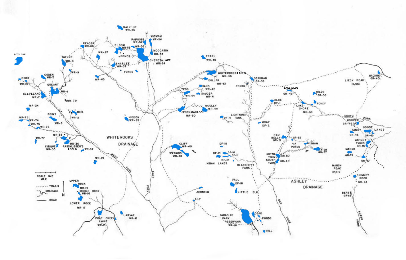
Whiterocks Drainage
The Whiterocks Drainge is one of the largest basins in the Uinta Mountains. Of its 80 lakes and ponds, over half support abundant populations of brook and cutthroat trout. Fishing pressure varies throughout the basin. A few lakes are regularly fished by anglers, while others may remain untouched for several seasons.
Whiterocks Drainage is divided into two sub-drainages: the East Fork and West Fork. The West Fork Lakes region begins with Pole Creek Lake which is located 15 miles north of Whiterocks via a dirt road. The East Fork Lakes region begins at Paradise Park Reservoir which lies 20 miles north of LaPoint—and is also accessed by dirt road. Both Whiterocks and LaPoint can be reached by taking oiled road which runs north and east of Roosevelt, UT.
| Lake name | Size (acres) | Max depth (ft) | Fish species | Fishing pressure |
|---|---|---|---|---|
| Chepeta, WR-64 | 50 | 60 | Brook (stocked) and cutthroat trout | High |
| Cleveland, WR-7 | 26 | 6 | Brook (stocked) and cutthroat trout | High |
| Cliff, WR-49 | 40 | 55 | Brook (stocked) and cutthroat trout | Moderate |
| Dollar, WR-43 | 7 | 15 | Brook, rainbow and cutthroat trout, Tiger trout | Moderate |
| Elbow, WR-58 | 25 | 17 | Brook trout (stocked) | Moderate |
| Figure-eight WR-56 | 3 | 5 | Cutthroat trout | Low |
| Hidden, WR-63 | 12 | 27 | Brook trout | Moderate |
| Larvae, WR-12 | 4 | 28 | Brook trout | High |
| Lower Rock, WR-17 | 12 | 39 | Cutthroat trout, Brook trout (stocked) | Moderate |
| Middle Rock, WR-16 | 6 | 10 | Brook and cutthroat trout | Low |
| Mocassin, WR-53 | 11 | 27 | Brook and cutthroat trout | Moderate |
| Ogden, WR-5 | 14 | 21 | Cutthroat and brook trout | Low |
| Papoose, WR-52 | 8 | 22 | Cutthroat and brook trout | Moderate |
| Paradise Park Reservoir, WR-18 | 137 | 36 | Rainbow trout (stocked) | High |
| Pearl, WR-45 | 2.5 | 15 | Brook trout (stocked) | Low |
| Point (Adams) WR-6 | 16 | 21 | Brook trout (stocked) | Low |
| Pole Creek Lake, WR-13 | 5 | 10 | Tiger trout, rainbow trout | High |
| Queant, WR-4 | 57 | 44 | Brook trout (stocked) | High |
| Rassmussen #1, WR-35 | 19 | 5 | Brook trout (stocked) | Moderate |
| Rassmussen #2, WR-36 | 14 | 8 | Brook trout (stocked) | Moderate |
| RC #1, WR-2 | 10 | 16 | Brook and cutthroat trout (stocked) | Low |
| Reader, WR-66 | 10 | 10 | Brook and cutthroat trout | Moderate |
| Sand, WR-42 | 6 | 5 | Brook and cutthroat trout | Low |
| Sharlee, WR-57 | 10 | 4 | Brook and cutthroat trout | Low |
| Taylor, WR-8 | 25 | 53 | Brook trout (stocked) | Low |
| Teds, WR-44 | 14 | 20 | Brook trout (stocked) | High |
| Upper Rock, WR-14 | 15 | 28 | Cutthroat trout (stocked) | Low |
| Walk-up, WR-55 | 13 | 60 | Brook trout | Low |
| Watkins, WR-48 | 18 | 36 | Brook trout | Low |
| Whiterocks Reservoir Lake, WR-46 | 35 | 42 | Brook and cutthroat trout | High |
| Wigwam, WR-54 | 4 | 14 | Brook and cutthroat trout (stocked) | Moderate |
| Wooley, WR-40 | 18 | 42 | Brook trout (stocked) | Moderate |
| Workman, WR-50 | 20 | 14 | Brook trout and cutthroat | Moderate |
| WR-9 | 3 | 12 | Brook trout | Low |
| WR-19 | 10 | 18 | Cutthroat trout | Low |
| WR-34 | 9 | 20 | Brook trout | Low |
| WR-37 | 3 | 13 | Cutthroat and brook trout | Moderate |
| WR-65 (Hell Hole) | 8 | 6 | Brook trout | Moderate |
| WR-67 (Horseshoe) | 12 | 14 | Cutthroat trout | Low |
| WR-73 | 8 | Unknown | Brook trout | Low |
| WR-74 | 4 | 14 | Brook trout | Low |
| WR-75 | 3 | 8 | Brook trout | Low |
| WR-76 | 8 | 7 | Brook trout | Unknown |
| WR-77 | 4 | 15 | Brook trout | Low |
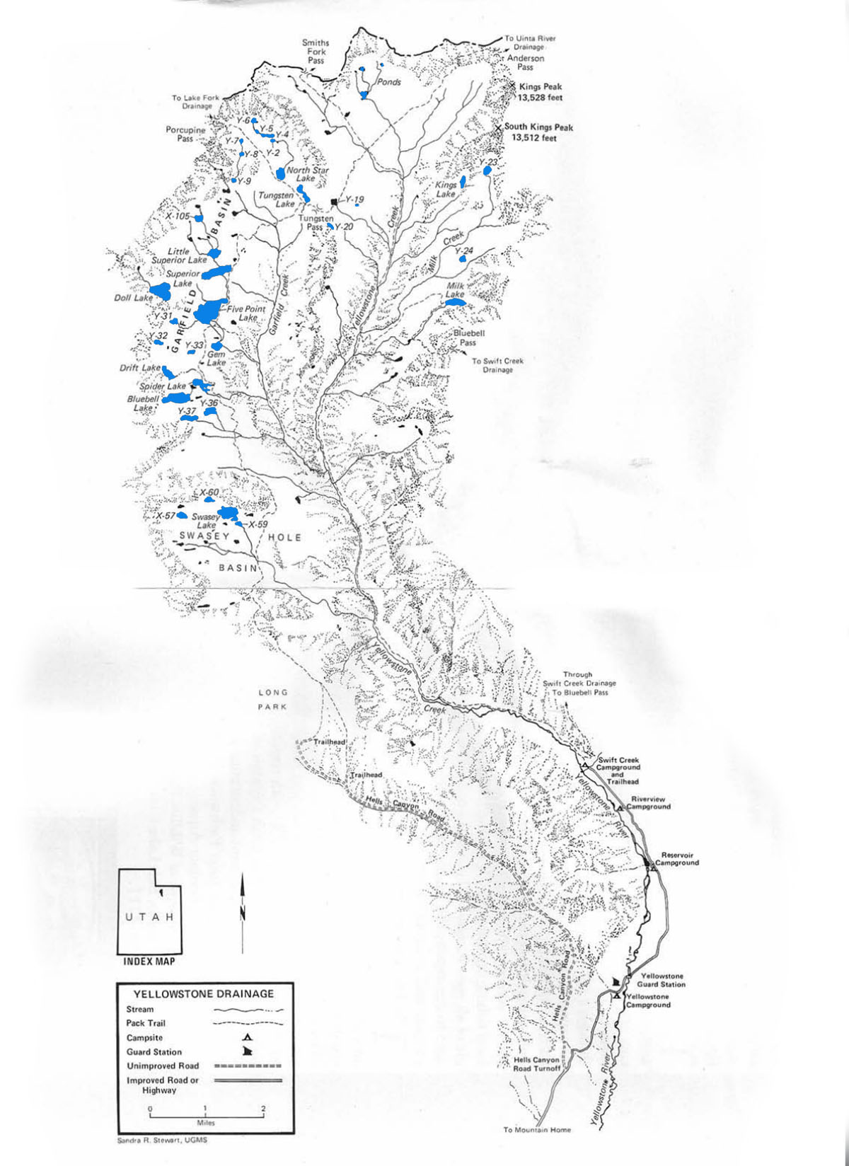
Yellowstone River Drainage
The Yellowstone River Drainage is centrally located within the Uinta Mountains. The majority of the drainage’s lakes and ponds are located long its west end. There are few fishable lakes along the east end. The drainage is sub-divided into three basins. These include the Garfield, Swasey Hole, and Tungsten Lake group basins.
The yellowstone river flows through the glacial formed valleys while most of the drainage’s lakes are located on the surrounding high mountain plateus. Like most of the drainages, the terrain in the Yellostone River Drainage is steep and rocky.
There are two routes into the Yellowstone River Drainage. These include (1) the Swift Creek trailhead at Swift Creek Campground and (2) the Hell’s Canyon trailhead at the bottom of Long Park. The Swift Creek trailhead is located about 4 miles north of the U.S. Forest Service Guard Station on Yellowstone River Road. The Hell’s Canyon trailhead is 7 miles up Hell’s Canyon Road from the junction between Hell’s Canyon Road and Yellowstone River Road. Both trails are well-maintained for foot and horse access.
Five Point Reservoir, Swasey Lake, Gem Lake, X-59 Lake and Spider Lake receive the most fishing pressure. The remaining lakes scattered throughout the drainage are much more inaccessible and receive little foot traffic or fishing pressure.
There are about 20 lakes in the Yellowstone River Drainage that are stocked periodically with Brook and Cutthroat trout. If you’re lucky you may also hook a rainbow or two. Naturally reproducing populations of brook trouts are found in several lakes including Doll, Bluebell, and Y-31 lakes. You’ll also find brookies and cutthroats throughout the drainage’s streams.
| Lake name | Size (acres) | Max depth (ft) | Fish species | Fishing pressure |
|---|---|---|---|---|
| Bluebell, X-10 | 38.3 | 32 | Brook and cutthroat trout (naturally reproducing) | Moderate |
| Doll, Y-16 | 42.5 | 47 | Brook trout | Low |
| Drift Reservoir, Y-41 | 14.8 | Unknown | Brook trout | Low |
| Five Point Reservoir, X-106 | 82 | 21 | Brook and cutthroat trout | Moderate |
| Gem, Y-34 | 11.1 | 15 | Brook trout (naturally reproducing) | Moderate |
| Kings, Y-22 | 10 | Unknown | Cutthroat trout | Low |
| Little Superior, X-104 | 13.9 | 24 | Brook trout | Low |
| Milk, Y-25 | 17.5 | 20 | Brook trout | Low |
| North Star, X-108 | 14 | 15 | Brook trout (naturally reproducing) | Moderate |
| Spider, X-109 | 20 | 31 | Brook and cutthroat trout | High |
| Superior, X-103 | 36 | 26 | Brook trout (naturally reproducing) | Moderate |
| Swasey, X-58 | 36 | 30 | Brook and cutthroat trout (naturally reproducing) | High |
| Tungsten, X-107 | 13 | 13 | Brook and cutthroat trout | Moderate |
| X-57 | 8.8 | 30 | Brook trout (naturally reproducing) | Low |
| X-59 | 4.5 | 13 | Brook and cutthroat trout | Moderate |
| X-60 | 8 | 30 | Cutthroat trout (stocked) | Low |
| X-105 | 8.1 | 14 | Cutthroat trout | Low |
| Y-2 | 1.8 | 20 | Brook trout (naturally reproducing) | Low |
| Y-4 | 5.8 | 12 | Brook trout (naturally reproducing) | Low |
| Y-5 | 1.8 | 6 | Brook trout (naturally reproducing) | Low |
| Y-19 | 6.2 | 15 | Brook trout | Low |
| Y-20 | 5 | 20 | Arctic grayling | Low |
| Y-31 | 4.6 | 7 | Brook trout (naturally reproducing) | Moderate |
| Y-36 | 14 | 15 | Brook trout | Low |
| Y-37 | 13 | 12 | Brook trout | Low |
Lake Fork Drainage
The Lake Fork Drainage is located on the south slope of the Uinta Mountain Range. It is subdivided into three tributaries: Lake Fork, Brown Duck, and Fish. All three of these tributaries flow into Moon Lake.
The main access to Lake Fork Drainage starts 15 miles north of Mountain Home, Utah at Moon Lake. The two major routes into the drainage are Brown Duck and Lake Fork trails. Brown Duck Trail runs 7 miles from Moon Lake into Brown Duck Basin. From there is splits into two trails that lead to Rock Creek Drainage (to the west) and north to Clements Reservoir and East Basin. The Lake Fork Trail runs north from Moon Lake along the main creek until it reaches Ottoson Basin, the Oweep Creek area, and Lambert Meadows. Both the Brown Duck and Lake Fork trails are well maintained.
Lake Fork Drainage has over 90 ponds and lakes—mostly located on the the thick timbered plateaus along the west end. Several of the lakes are over 20 miles from the drainage’s main access point at Moon Lake. Lake Fork drainage is also home to Crater Lake, the deepest natural lake in the Uintas.
Some of most popular fishing destinations for anglers include Brown Duck Basin, the Clements Reservoir area and the Atwine Lakes area. Each of these destinations is within 7-11 miles of the main trailhead at Moon Lake. Fishing pressure is at its highest over the July 4th, 24th of July and Labor Day holidays. If you want solitude, peace, or quite, avoid these dates. All other lakes and basins receive low to moderate fishing pressure.
Roughly half of the lakes in the drainage provide abundant fish populations and fishing opportunities. The main game fish include brook and cutthroat trout, with a few rainbows and Arctic graylings mixed in. The most abundant trout populations are found in Crater, Atwine, and Porcupines lakes. Most of the larger streams provide excellent fly fishing for brook and cutthroat trout.
| Lake name | Size (acres) | Max depth (ft) | Fish species | Fishing pressure |
|---|---|---|---|---|
| Ameba, X-90 | 4.6 | 4 | Cutthroat trout (stocked) | Low |
| Aspen, X-63 | 8 | 26 | Brook trout (stocked) | Moderate |
| Atwine, X-64 | 32 | 35 | Brook trout (natural reproducing) | Moderate |
| Big Dog, X-32 | 6 | 12 | Arctic grayling | Low |
| Brown Duck, X-31 | 30.7 | 12 | Cutthroat trout (natural and stocked) | High |
| Clements, X-74 | 79.2 | 50 | Cutthroat trout (naturally reproducing) | Moderate |
| Crater, X-94 | 28 | 147 | Brook trout | Low |
| East Slide, LF-44 | 5 | Unknown | Brook trout (stocked) | Low |
| Gates, LF-34 | 5.4 | 20 | Brook trout | Low |
| Hook, X-81 | 21 | 19 | Brook trout (stocked) | Low |
| Island, X-34 | 66 | 48 | Cutthroat trout, Tiger trout | High |
| Kidney, X-35 | 190 | 112 | Cuthroat and brook trout | Moderate |
| Lambert, LF-21 | 6.6 | 15 | Brook trout (stocked) | Moderate |
| LF-8 | 7 | 17 | Unknown | Low |
| LF-16 | 3 | 6 | Brook trout (stocked) | Low |
| LF-35 | 1 | 6 | Brook trout (natural reproducing) | Low |
| LF-37 | 1.9 | 3 | Brook trout (stocked) | Low |
| LF-43 | 1.4 | 4 | Brook trout | Low |
| Lilly Pad, X-37 | 1.4 | 8 | Brook and cutthroat trout (naturally reproducing) | Moderate |
| Linda, LF-36 | 3.8 | 5 | Brook trout | Low |
| Little Dog, X-33 | 4.5 | 17 | Brook trout (stocked) | Low |
| Moon Lake | 49.8 | n/a | Brook trout, Mountain whitefish, Rainbow trout, Splake, Cutthroat trout, Kokanee salmon, Tiger trout, Arctic grayling | High |
| Mud, X-66 | 2.5 | 5 | Brook trout (stocked) | Low |
| Oweep, LF-30 | 6.4 | 16 | Brook trout | Low |
| Ottoson, Lower, X-88 | 9.1 | 8 | Cutthroat trout (naturally reproducing) | Low |
| Ottoson, Upper, X-87 | 12.4 | 30 | Cuthroat trout | Low |
| Picture, X-82 | 20 | 13 | Rainbow trout | Low |
| Porcupine, LF-22 | 12.8 | 14 | Brook trout (naturally reproducing) | Low |
| Stewart, X-79 | 9.2 | 22 | Brook trout (stocked) | Low |
| Toquer, LF-25 | 11.1 | 32 | Brook and cutthroat trout | Low |
| Twin, X-77 | 12.9 | 15 | Brook trout (stocked) | Low |
| Tworoose, X-36 | 21.9 | 37 | Cutthroat trout (naturally reproducing) | Moderate |
| X-61 | 5.2 | 10 | Cutthroat trout | Low |
| X-62 | 6 | 10 | Cutthroat trout | Low |
| X-75 | 4.4 | 6 | Cutthroat trout | Low |
| X-78 | 17 | 18 | Cutthroat trout | Low |
| X-80 | 4.6 | 5 | Brook and cutthroat trout (naturally reproducing) | Low |
| X-84 | 4.6 | 18 | Brook trout (stocked) | Low |
| X-85 | 4.7 | 14 | Brook trout | Low |
| X-86 | 6.9 | 12 | Brook trout (stocked) | Low |
| X-89 | 3.4 | Unknown | Unknown | Low |
Swift Creek Drainage
Compared to other drainages in the Uinta Mountains, Swift Creek Drainage is small and steep-sided. It is characterized by a rapidly flowing stream through its center and lakes that sit high above on timbered plateaus. It has 17 large lakes and several smaller ponds. Most of the fishable lakes are located in the Timothy Lakes Basin and Farmers Lake area.
Access to Swift Creek Drainage begins at the Swift Creek Campground about 15 miles north of Mountain Home, Utah. The main trail into the drainage is well maintained, but steep and rocky. Fishing pressure is highest at Deer, White Miller, and East Timothy. Camping is best at White Miller, Lily, East Timothy, X-30 and Center Timothy. If you’re traveling by horse, you’ll find the best horse feed at White Miller, X-25, X-24 and East Timothy.
| Lake name | Size (acres) | Max depth (ft) | Fish species | Fishing pressure |
|---|---|---|---|---|
| Carrol, East, X-21 | 10 | 19 | Cutthroat trout | Moderate |
| Carrol, Lower, X-17 | 9 | 7 | Brook trout | Moderate |
| Carrol, Upper, X-18 | 35 | 48 | Brook trout | Moderate |
| Deer, X-55 | 12 | 4 | Brook and cutthroat trout (naturally reproducing) | High |
| Farmers, X-23 | 63 | 24 | Brook trout (stocked) | Moderate |
| Grayling, X-56 | 8.5 | 33 | Brook trout | High |
| Lily, S-15 | 20 | 39 | Brook trout (stocked) | High |
| Timothy, Center, X-20 | 10 | 18 | Brook trout (naturally reproducing) | High |
| Timothy, East, X-16 | 40 | 35 | Cutthroat trout | High |
| Timothy, West, X-19 | 45 | 45 | Brook trout | Moderate |
| Twin, X-49 | 14 | 15 | Cutthroat trout | Moderate |
| White Miller, X-54 | 11 | 18 | Brook trout (stocked) | High |
| X-22 | 9 | 8 | Brook and cutthroat trout | Moderate |
| X-24 | 21.4 | 30 | Cutthroat trout (stocked) | Low |
| X-25 | 15.9 | 27 | Cutthroat trout | Moderate |
| X-26 | 7.7 | 23 | Brook trout | Low |
| X51 | 5 | 8 | Cutthroat trout | Low |