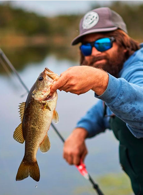
Running from the Uinta Mountains to the town of Provo, Utah, the Provo River offers scenic views and world class fishing. About 15 miles of the river offers fishable access, spread across the river’s Upper, Middle, and Lower sections. The Middle and Lower stretches of the Provo River are notable for their consistent stream-flow that allows plenty of streamer, dry fly, and nymph fishing year-round. The Middle Provo is the place to go for giant brown trout, with 18 inch-plus specimens caught year-round by fly fishermen using a range of techniques. In the Lower section of the river, the rainbow trout are on average the largest in the state, thanks to a nutrient-rich diet of midge larva and sow bugs.
Provo River Fishing Map
The following map shows the access points and fishing spots for Upper, Middle and Lower Provo River fisheries.
Where to Fish the Provo River
The Provo River is divided into three distince fisheries: Lower Provo River, Middle Provo River, and Upper Provo River. Each fishery provides distinct, yet excellent fishing opportunities.
The lower and middle stretches of the Provo River are both tailwater fisheries where brown and rainbow trout are the primary game fish. Brown and rainbow trout in these stretches of the river are numerous and can grow quite large. While not as plentiful, angers can also expect to hook an occassional cutthrout trout. The predominant method of fishing on the Middle Provo and Upper Provo rivers is fly fishing.
The Upper Provo River contains mostly brook trout and cutthroat trout, with a frew browns and rainbows intermixed. In relation to the lower and middle provo rivers, the fish in the Upper Provo River are a bit smaller on average, but you’ll still find a few giants here as well.
Lower Provo River
The Lower Provo River extends from I-15 east upstream through town to Olmstead Diversion in Provo Canyon, and from there to Deer Creek Dam. Access along the lower length of the Provo river from I-15 to where the river enters the canyon is limited, but there are access points where anglers can fish. From the mouth of Provo Canyon upstream to Deer Creek Dam, the river is accessible to anglers at various spots along HWY 189.
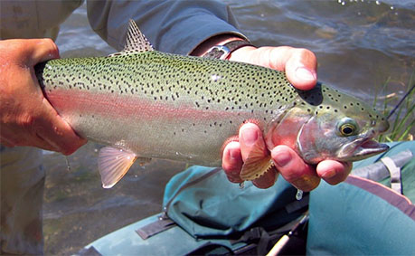
The primary game fish species in the Lower Provo River are Brown and Rainbow trout. Trout along this section of the Provo river are well fed and can grow in excess of 20 inches. Other fish species include Mountain Whitefish, Cutthroat and Bonneville Trout.
Fishing the Lower Provo River is best during the spring and early summer when water levels are highest, but anglers can fish this stretch of the river year round. Mayfly, blue winged olive, and dun hatches in early spring and mid summer provide excellent dry fly fishing opportunities. Aquatic food sources in the river include scuds, sow bugs an midges. Trout along the Lower Provo River can be finicky feeders so it’s important to match the hatch.
The Lower Provo River west of I-15 downstream to Utah Lake State Park is slow and flat. Fishing here is limited to a few Brown Trout but predominantly warmer water species including Carp, Channel Catfish, Bullhead Catfish, White Bass, Crappie and Sunfish, in that order.
During the mid to late summer the Lower Provo River is heavily trafficked by visitors, tourists, tubers, and river running outfits.
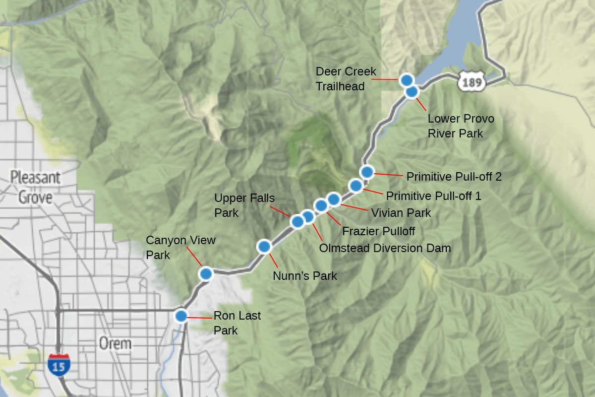
The following map and table provide the access points and coordinates fishing along Lower Provo River in the Provo Canyon.
| Access Point | Description |
|---|---|
| Lower Provo River Park | Public access for anglers. Offers shore and wading fishing 8950 Lower Deer Creek Rd, Heber City, UT 84032 (435) 654-0171 Coordinates: 40.401781, -111.530717 Directions |
| Olmstead Diversion Dam | A favorite fishing spot for local trout anglers Provo River Pkwy, Provo, UT 84604, United States Coordinates: 40.349195, -111.588390 Directions |
| Vivian Park Trailhead | Trout fishing along shore. Small fishing area for kids 12 and under Coordinates: 40.356244, -111.574040 Directions |
| Upper Falls Park | Provides access to a nice fishing spot for brown trout Coordinates: 40.347074, -111.593943 Directions |
| Nunn's Park | Great place to camp and fish for trout E Provo Canyon Rd, Provo, UT 84601 (801) 851-8640 Coordinates: 40.336470, -111.612422 Directions |
| Canyon View Park | Located just outside of Provo Canyon. Offer access to Provo river for fishing. You'll find trout and bass. 2383 E Provo Canyon Rd, Provo, UT 84604 Coordinates: 40.325265, -111.644224 Directions |
| Ron Last Park | Small park with a few public access fishing spots. Ron Last Park, Provo, UT 84604 Coordinates: 40.307265, -111.658402 Directions |
| Vivian Park | 9 miles up Provo Canyon. Likely catch Rainbow Trout, possibly Brown Trout Coordinates: 40.356345, -111.573564 Directions |
| Frazier Pull off | 3362 E Provo Canyon Rd (milepost 12.7, Provo, UT 84604 Coordinates: 40.353756, -111.580631 Directions |
| Primitive Pull-off 1 | River Access on south side of road Coordinates: 40.362071, -111.561065 Directions |
| Primitive Pull-off 2 | River Access on south side of road Coordinates: 40.368230, -111.554851 Directions |
| Deer Creek Park | Access on south side of road Coordinates: 40.397753, -111.537677 Directions |
| Deer Creek Trail | Access on north side of road: Provo-Jordan River Parkway, Wallsburg, UT 84082 Coordinates: 40.406444, -111.533350 Directions |
The following table provides the access points and coordinates for fishing along Lower Provo River in the Provo Canyon.
| Access Point | Description |
|---|---|
| Provo River Walk | Great fishing for trout Provo River Pkwy, Provo, UT 84604 Coordinates: 40.256165, -111.664577 Directions |
| Provo River Park | Offers several fishing spots. Many white bass here. 335 N Geneva Rd, Provo, UT 84601 (801) 852-6606 Coordinates: 40.243858, -111.694768 Directions |
| Alligator Park | River is slow and deep here. Provides fishing for warm water species. Coordinates: 40.238839, -111.721882 Directions |
| Provo River Trailhead | Provide public access to ample shore fishing for some trout and mostly warm water species Coordinates: 40.241396, -111.685313 Directions |
| West Provo River Trailhead | Provides shore fishing access along the trail. Mostly carp, catfish and bass fishing Coordinates: 40.238381, -111.732862 Directions |
| Utah Lake State Park | Access to the Provo river outlet. Fishing is for carp, catfish, bass and an occassional pike Coordinates: 40.238169, -111.736170 Directions |
| Provo River Parkway | Provides extended shore access to the lower west Provo river. Warm water fish species found here. 1199 W 650 N St, Provo, UT 84601 Coordinates: 40.242721, -111.680079 Directions |
Middle Provo River
The Middle Provo River is a tailwater fishery of Jordanelle Reservoir. It extends east from Deer Creek Reservoir upstream through the Heber Valley to Legacy Bridge SR-113 and from there to Jordanelle Dam. As a tailwater fishery, the Middle Provo River experiences stable water temperatures and flows year round. Water temperatures tend to remain relatively cooler throughout the summer and warmer in the winter.
The Middle Provo River has been established as a first class Blue Ribbon Fishery. It offers fishing for Brown, Rainbow and Cutthroat Trout. Other species found here include Mountain Whitefish and an occassional Walleye. The most common fish methods are fly fishing and bait casting. Most serious anglers bring a pair of waders but fishing from shore is also popular.
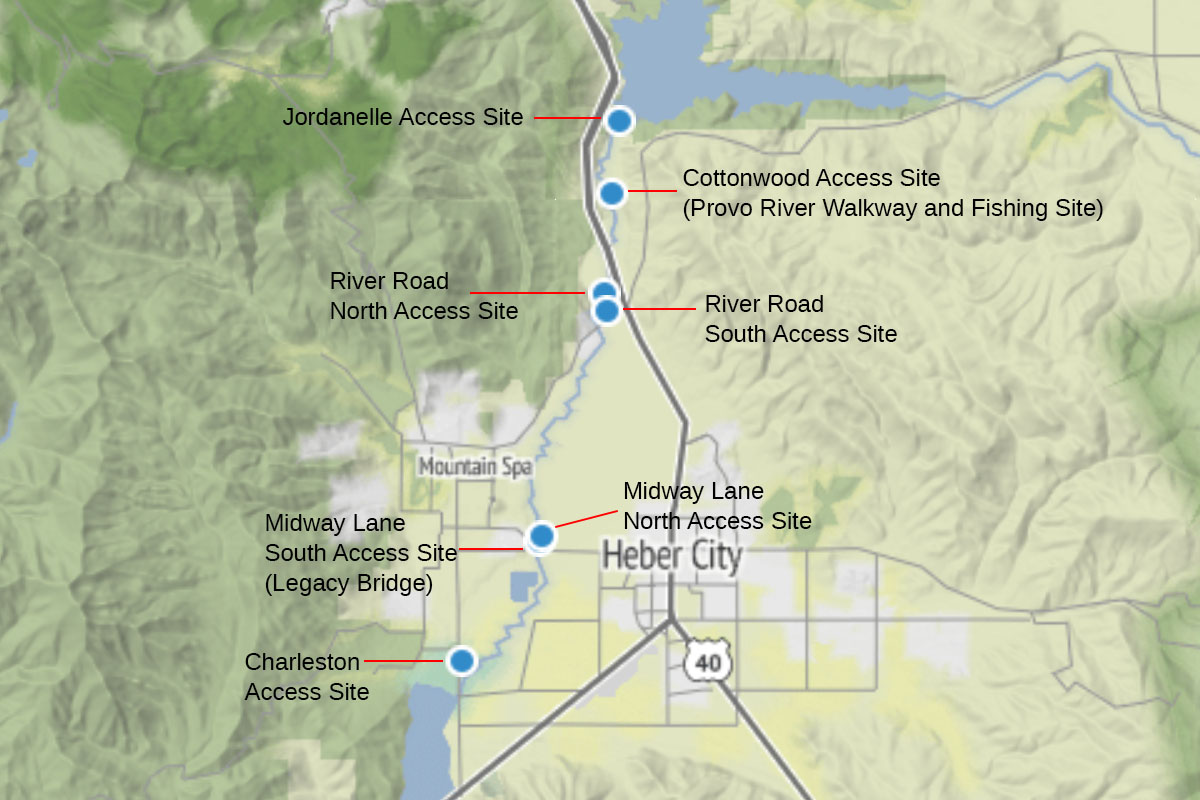
The Middle Provo River is just over 12 miles long and between 10 to 30 feet wide. Most of the Middle Provo passes through private property but the city has established a pulic access cooridor with seven access points. River access is available at Charleston Bridge in Charleston, on Midway Lane near Legacy Bridge, downstream from Highway 40 near Midway junction, and at a public access site just below Jordanelle Dam.
The following map and table provide the direction and coordinates of all 7 public access points along the Middle Provo River.
| Access Point | Description |
|---|---|
| Jordanelle Access Site | Located just below Jordanelle Dam Coordinates: 40.594878, -111.427923 Directions |
| Cottonwood Access Site (Provo River Walkway and Fishing Site) | Provides public access for ample shore fishing. Access along both sides of the river. HHHC+C2, Daniel, UT 84032 Coordinates: 40.579490, -111.429901 Directions |
| River Road North Access Site | 3975 River Rd, Heber City, UT 84032 Coordinates: 40.558481, -111.431965 Directions |
| River Road South Access Site | Located just south of the River Road North Access Site in Midway, Utah Coordinates: 40.554915, -111.431755 Directions |
| Midway Lane North Access Site | GH52+855 Midway, Utah Coordinates: 40.508273, -111.449512 Directions |
| Midway Lane South Access Site (Legacy Bridge) | Parking with river access along Midway Lane between Midway and Heber City 2777-3059 S 400 E, Midway, UT 84049 Coordinates: 40.507138, -111.450015 Directions |
| Charleston Access Site | Just north of Charleston, Midway UT off HWY 113 Coordinates: 40.481764, -111.471283 Directions |
Upper Provo River
The Upper Provo River offers world class fishing for several species of trout, including Browns and Cutthroats. This section of the Provo river also offers fishing for Mountain Whitefish and a few Kokanee Salmon.
Unlike the Middle Provo, the Upper Provo River is a freestone river. Water flow is dependent on runoff and varies throughout the year. Flow tends to be heavier during the spring and summer, and lighter in the fall and winter.
The Upper Provo River runs southeast from Jordanelle Reservoir upstream to the confluence with north and south forks at the headwaters of the Uinta Mountains. Public access for fishing is most abundant within National Forest boundaries. Public access is available east of Woodland off State Hwy 35 and further north along the scenic Mirrorlake Highway (UT 150). Outside of national forest boundaries, much of the Upper Provo River runs through private property.
From the Jordanelle Reservoir upstream 3/4 of a mile anglers can access the river via a Walk-in Access agreement between the Utah Division of Wildlife Resources (UDWR) and private land owners. Anglers who wish to fish this stretch of the Upper Provo River located on private property must obtain a walk-in-access authorization number from the UDWR.
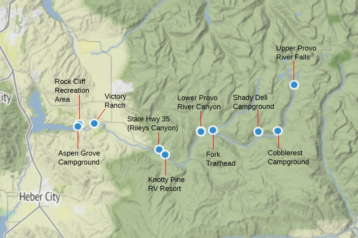
The following map and table provide the access points and coordinates for fishing along Upper Provo River.
| Access Point | Description |
|---|---|
| Rock Cliff Recreation Area | Provide access where the Provo River meets the Jordanelle Reservoir. Good access for fishing Coordinates: 40.603525, -111.341612 Directions |
| Aspen Grove Campground | Provides access to where the Provo river flows into Jordanelle Reservoir. Good fishing for brook, brown and cuttroats Coordinates: 40.600558, -111.343176 Directions |
| Victory Ranch | Private 4 mile stretch that offers excellent fly fishing for brown, rainbow, brook and cutthroat trout 7865 N Victory Ranch Rd, Kamas, UT 84036 435-785-5000 Coordinates: 40.604671, -111.313903 Directions |
| State Hwy 35 (Rileys Canyon) | From where the Provo River intersects with State Hwy 25 at Rileys Canyon to where Hwy crosses over the Provo River about 2 miles down the road at Bull Moose Rd there are several access points just off the highway that provide good fishing for brown, rainbow, and cutthroat trout. Coordinates: 40.568038, -111.194272 Directions |
| Knotty Pine RV Resort | Provides parking, overnight camping and direct access for fishing a large stretch of the Provo River 5175 E State Hwy 35, Kamas, UT 84036 Coordinates: 40.561233, -111.183134 Directions |
| Mirrorlake Highway (UT 150) | From where the Provo River intersects with Mirror Lake Highway (UT 150) near Lower Provo River Campground upstream 13 miles to Trail Lake there are several public access points for fishing the Upper Provo River. Coordinates: 40.594395, -111.116604 Directions |
| Upper Provo River Falls | Provides good fishing for trout. Popular fly fishing destination for anglers. Coordinates: 40.658736, -110.945224 Directions |
| Lower Provo River Campground | Provides parking, overnight camping and direct access to a large stretch of good fishing area. Wasatch Cache National Forest, FR053, Kamas, UT 84036 Coordinates: 40.593595, -111.116666 Directions |
| Fork Trailhead | Public parking. Short walk to the Provo River. Coordinates: 40.595307, -111.094827 Directions |
| Shady Dell Campground | Overnight camping and access to Provo River. UT-150, Kamas, UT 84036 Coordinates: 40.592883, -111.011471 Directions |
| Cobblerest Campground | Overnight camping and access to Provo River. FR096, UT-150, Kamas, UT 84036 Coordinates: 40.594409, -110.975883 Directions |
The Best Places to Fish The Provo River
The best place to fish the Provo River is really determined by how you define “best”. Each access point and stretch along the river provides a different type of fish and fishing experience.
If you like fishing a free flowing river, want to avoid the crowds, and are looking for truly wild brook and cutthroat trout, the upper section is probably right down your alley. However, this stretch doesn’t provide quite the public access as the middle and lower stretches.
The Middle Provo River provides breathtaking landscape and beautiful views, constant year round flow, with the highest concentrations per mile of brown trout and rainbow trout. Anglers constantly report that this section of the Provo River is the best producing, with a relatively high percentage of trophy catches.
The Lower Provo River is the most accessible section of the Provo River. And as a tailwater of Deer Creek Reservoir tends to experience relatively stable water flow and conditions. Trout here are big and plentiful.
If you have the time and disposition, I recommending giving all three sections of the Provo River a try. Each has something unique to offer. All three sections are world class fisheries.
Recommended Fishing Techniques
Provo River is home to three distinct cold water fisheries. The Upper Provo, Middle Provo, and Lower Provo. Each fishery has varying water conditions and fish populations that require different fishing techniques and approaches.
The predominant fishing method on the Upper Provo River is dry fly fishing. Attractor dry flies along with small ants, hoppers, stoneflies, and beetles are trout favorites. Fly patterns that always seem to do the trick include Elk Hair Caddis, Parachute Adams, and Chubby Chernobyl. I recommend fly sizes between 12 and 16. In the upper section of the Provo River it’s artificial flies and lures only.
The Middle Provo River is known for two things: finicky trout and prolific mayfly hatches, both of which have to be taken into consideration when fishing this 12 mile stretch of the river. The Middle Provo River is a bucket-list river for many a fly fisherman, but it ain’t always easy catching trout here.
The Middle Provo requires light tippets, small flies and good fishing technique. The predominant hatches are Pale Morning Dun (PMD), Blue Winged Olive (BWO) and Green Drake. Match the hatch! During winter months, midges and streamers are the most productive flies on the Middle Provo. As on the Upper Provo, artificial flies and lures only along this stretch.
The upper reaches of the Lower Provo River from Olmstead Diversion Dam upstream to Deer Creek Dam is a traditional tailwater fishery similar to Middle Provo River. This stretch of river has clear, crisp mountain water with healthy populations of brown and rainbow trout. Fly fishing techniques described for the Middle Provo River are also effective for fishing the upper reaches of the Lower Provo River.
Downstream from Olmstead Diversion Dam river conditions changes drastically. Brisk flows and rapids are exchanged for shallow riffles and pocket water. You’ll still find ample populations of trout throughout the Lower Provo River from Olmstead Diversion Dam on downstream. Here traditional fishing as well as lure fishing are popular techniques.
Water flow slows and the cold water fishery give way to warmer waters as the Lower Provo River reaches Utah Lake. Fishing techniques along this stretch will vary based on target fish species.
When to Fish the Provo River
As a high-elevation river, the Upper Provo is locked in snow a good portion of the year. Fishing really doesn’t get underway until after spring runoff in late June to early July. By this time of the trout are hungry and ready to feed. The best months to fish the Upper Provo are July through September, but this section of the Provo River can be fished until late fall.
As a tailwater river of Jordanelle Reservoir, the Middle Provo River offers stable water flow and conditions year round. You can wet your line here any time of year, but the best fishing months are late May through early July (or whenever spring runoff subsides.) Fishing is good throughout the fall and winter months as well. Whatever time you decide to fish the Middle Provo, catching trout here requires patience and persistence.
The Lower Provo River can be fished year round. However, the best time to fish the Lower Provo from the mouth of Provo canyon upstream is during the spring–coinciding with Blue Winged Olive (BWO) hatches. During the summer months expect to compete for prime fishing areas with tubers floating the river.
Check the provo river fishing report for current fishing conditions and details.
Provo River Fish Species


Provo River boat ramps:
The following boat ramps provide access to Provo River.
Utah Lake State Park #5 Boat Ramp
S Jetty Rd, Provo, UT 84601, USA
Directions
Watkins Glen Yacht Club Boat Ramp
4261-4369 N Jetty Rd Provo, UT, USA
Directions